Survey to Map Seabed and Potential Hazards Off English North Sea Coast
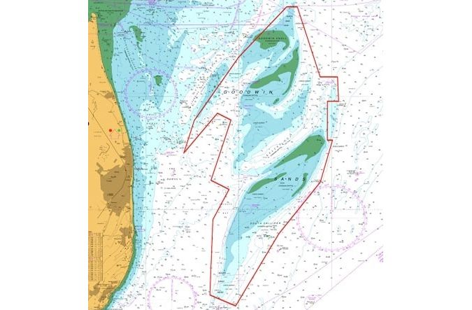
For centuries, the Goodwin Sands – a 16km-long sandbank at the southern end of the North Sea off the coast of Kent, England – have posed a navigational threat to mariners, largely because they were completely unmarked and uncharted. Strong currents and tides constantly shift the sand around, changing the edges of the sandbank. An out-of-date chart can make all the difference between a safe passage and running aground.
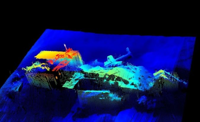
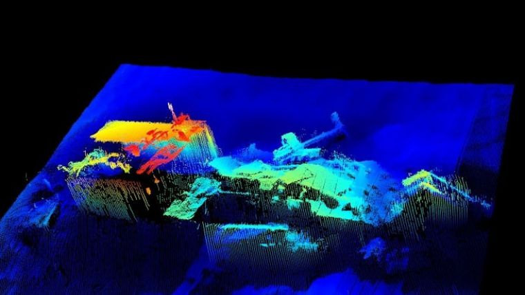
Different areas of the Goodwins are now surveyed on a regular basis and this past month has seen a routine resurvey of the whole area, undertaken for the Maritime & Coastguard Agency (MCA) as part of their Civil Hydrography Programme. This full survey is carried out every 12 years. The detailed high-resolution multibeam echosounder maps the shifting seabed and identifies potential navigational hazards such as obstacles, as required by the International Convention for the Safety of Life at Sea (SOLAS).
The survey is being carried out by contractors A-2-Sea Solutions using their advanced 20m survey vessel FPV Morven. Morven can accommodate up to six marine and survey crew – sadly not enough to continue the Royal Navy Hydrographers’ tradition of playing cricket on the Sands!
Multibeam Echosounder Data Collection
Data collected by the multibeam echosounder is processed on board and sent to both the MCA and the UK Hydrographic Office (UKHO). Following completion of validating and analysis, the data will then be incorporated into a new edition of the Admiralty chart number 1828, likely to be published in early 2022. The survey team also recorded seal sightings – locations and numbers – thereby identifying the current haul-out sites.
As well as updating the Admiralty chart, the data collected will be used to produce a report comparing the changes in water depths since the last full survey in 1997. Significant discoveries are sent straight to the UKHO, who will in turn issue a Notice to Mariners with immediate effect.
Paula English, the MCA’s hydrography programme lead, said the work was a vital part of keeping those at sea safe. “The areas of highest navigational safety risk within UK waters have to be and are surveyed systematically,” she explained. “The lives of mariners can and do depend on it.
“In January 1946, the American Liberty ship Luray Victory ran aground on the Goodwin Sands and broke apart the following day. Her crew of 49 were rescued. Remains of the vessel were visible from the Kent shore for many years. Over the past centuries, about 2,000 ships have been wrecked on the Goodwin Sands, which are situated close to the major shipping lanes through the Straits of Dover.
“The CHP and the MCA work together in close partnership with the UKHO to make sure the nation’s nautical charts and publications are current, accurate and fit for purpose. It means that mariners can make informed and safe decisions about their choice of vessel route to make sure they avoid potential hazards, protecting themselves, their crew, shipping and the marine environment.”
The original version of this article was published by The Isle of Thanet News.