TCarta expands Seabed 2030 involvement with capacity-building training programmes
TCarta Marine, a global provider of hydrospatial products and services, is expanding its involvement in the Seabed 2030 project. The initiative aims to map the entire ocean floor by 2030, and TCarta has already contributed extensive satellite-derived bathymetry data to the effort. Now, the company will offer capacity-building initiatives to train international hydrographic offices in creating their own datasets for Seabed 2030 and other applications.
Launched by The Nippon Foundation of Japan and the General Bathymetric Chart of the Oceans programme (GEBCO), Seabed 2030 aims to create a publicly accessible bathymetric dataset of the seafloor. The project is officially endorsed by the UN Decade of Ocean Science for Sustainable Development, highlighting the importance of this work.
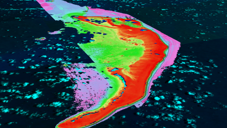
As a Seabed 2030 partner, TCarta has already contributed an impressive 150,000 square kilometres of ten-metre-resolution seafloor depth measurements through its Global Satellite-Derived Bathymetry (G-SDB) product line. This includes areas such as the Red Sea in the Middle East and Caribbean coastal zones of Belize and Turks and Caicos. TCarta’s continued contributions to this vital project demonstrate its commitment to global ocean mapping efforts.
“Seabed 2030 is making these bathymetric datasets available for coastal resilience, environmental protection and other important applications outside of traditional nautical charting”, said TCarta president Kyle Goodrich.
Employing new exploration techniques
“In 2022, TCarta provided high-resolution bathymetric coverage of areas where little to no data was previously accessible to the public”, said Hayley Caitlin Drennon of the Lamont-Doherty Earth Observatory. “The data collected in the Caribbean and Indian Ocean provides first-order information of the seafloor surrounding coastal communities most at risk to sea-level rise. The importance of its work was immediately seen in a partner project, Monaco Explorations, which utilized data collected by TCarta around Mauritius and Seychelles in its 2022 Indian Ocean Mission to fulfil its goals of protecting the biology of the region while also employing new exploration techniques.”
TCarta has taken its Seabed 2030 participation a step further by developing capacity-building training programmes to instruct international hydrographic offices in the production of SDB data for their coastlines. TCarta personnel completed training with the Mexican Hydrographic Office in 2022. The firm will begin a similar instructional programme in Jamaica this year with an export grant from the State of Colorado.
“Starting with Mesoamerica, our goal is to empower smaller nations to create their own high-quality bathymetric products for the protection and sustainable development of their coastal resources”, said Goodrich. “They are free to contribute the derived datasets to Seabed 2030 and to incorporate them into their own projects.”
The capacity-building sessions train participants in the use of TCarta’s Trident (SDB) Toolbox, a series of software applications that operate within Esri ArcPro to extract bathymetric measurements from satellite, aerial and UAV imagery using machine learning and satellite-based Lidar technology. The generated G-SDB data contain bathymetric measurements to depths of more than 30 metres, depending on water clarity, at ten-metre resolution.


