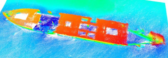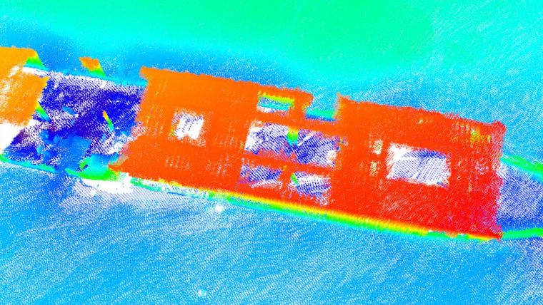
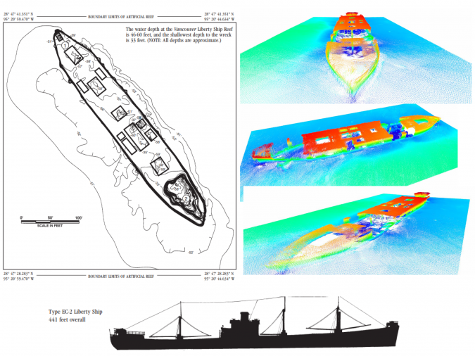
TDI-Brooks Maps the Liberty Ship Reef Site George Vancouver
TDI-Brooks recently mapped the Liberty Ship George Vancouver Reef off Freeport, Texas while out on a seabed survey project with the RV Brooks McCall. The multiple multi-phase geophysical and geotechnical site surveys programme consisted of pipeline routing and subsea structures to facilitate route and project design for offshore developers.
Equipment used to map the ship was a Teledyne Reson SeaBat T-20 multibeam sonar with integrated Applanix POSMV for Motion. Applying the mesh tools to the multibeam survey shows an example of the shipwreck.
Texas has been involved in artificial reef development for nearly 50 years. Numerous reef building materials have been used over the years. However, the first highly successful artificial reef development occurred during the mid-1970s when 12 obsolete Liberty Ships were sunk at five different sites in the Gulf of Mexico. During deployment to the Freeport Liberty Ship Reef site in 1976, the Vancouver sank during a storm and settled to the bottom of the Gulf at its present position. Eleven other Liberty Ships and two tankers are located at other reef sites along the Texas coast. Brochures for these reef sites are available from the Texas Parks and Wildlife Department.
Site-specific Geotechnical Data
The multi-phase geophysical surveys performed all included the integration of bathymetry, side-scan sonar, sub-bottom profiling and magnetometer data. Side-scan sonar data was used to determine areas of the seabed with contrasting acoustic properties that relate to different seabed sediment composition, sedimentary features and rock outcrop. The purpose of the geotechnical site survey was to gather sufficient site-specific geotechnical data for the design and installation of the offshore facilities. The geotechnical assessment included box cores, piston cores and CPTs throughout the routes and terminal areas.
Hydrographic marine surveys are critical to any site investigation and/or seabed mapping project. Hydrographic surveying is the science of measuring and describing features that affect maritime navigation, marine construction, dredging, offshore oil exploration/drilling and related activities. Strong emphasis is placed on soundings, shorelines, tides, currents, seabed and submerged obstructions that relate to the previously mentioned activities.
Each TDI-Brooks vessel uses its multibeam echosounder to conduct hydrographic surveys. Multibeam sonar measures the depth of the sea floor by analysing the time it takes for sound waves to travel from a boat to the seafloor and back. In addition to our onboard services, we offer portable tool kits which can be shipped to any vessel of opportunity.