Terradepth Unveils Absolute Ocean Marine Data Platform
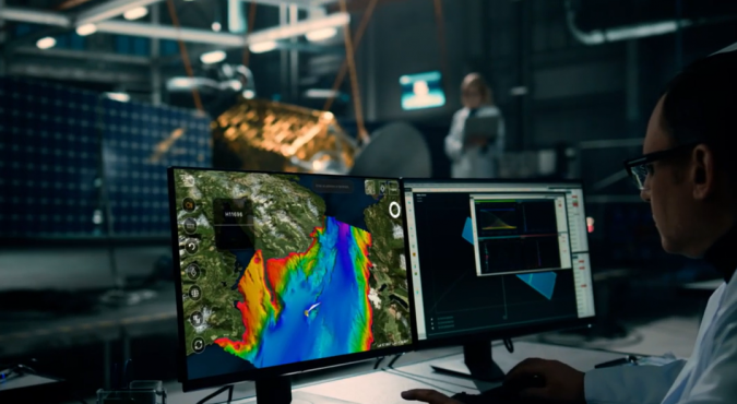
Terradepth has launched Absolute Ocean (AO), a cloud-based geospatial solution providing high-level visualization, analysis, collaboration and management of all marine data. In addition to offering Absolute Ocean as a software-as-a-service solution, Terradepth leverages the platform to deliver its own marine survey products – including autonomous underwater vehicle (AUV) data – as well as those of third-party ocean data vendors.
The Texas-based provider of seafloor hydrographic and geophysical survey solutions developed Absolute Ocean to deliver greater operational efficiencies in marine data delivery and collaboration. Absolute Ocean has been available in beta since early 2022 with several early adopters exercising its functionality. Currently, the solution is being used for projects ranging from environmental monitoring and construction engineering to offshore energy production and telecommunications infrastructure inspection.
“Absolute Ocean breaks open the data silos that have traditionally impeded access to, and collaboration on, vital ocean information,” said Joe Wolfel, CEO of Terradepth. “This fully integrated platform allows marine organizations to manage and archive all of their data sets in one place for enterprise-wide access and global collaboration.”
Transforming Ocean Data Management
Absolute Ocean is intuitive, enabling multiple stakeholders, most of whom did not previously have easy access to this data, to easily manage, view, analyse and deliver ocean geospatial information. Absolute Ocean addresses the need for a unified 3D geospatial data platform for secure enterprise-wide data sharing and visualization, as well as regulatory compliance.
“Terradepth’s Absolute Ocean revolutionizes ocean data management,” said Damon Wolfe, president of ECHO81, a premier supplier of underwater survey technology and Terradepth reseller based in Hartwell, Ga. “This easy-to-use interactive interface offers a long-needed solution for managing complex maritime data sets.”
Users can easily and securely upload geospatial data in any format into the secure cloud database directly from Absolute Ocean’s web browser interface. They can then query and visualize the data and perform geospatial analysis. Users can also generate and send hyperlinks that allow other stakeholders to see the exact view and projection on screen for easy collaboration.
Data-driven Decisions
A powerful geospatial engine enables users to view marine data and the base map data sets in 2D and 3D, from a variety of perspectives, scales and viewing angles. Linear distances, profile measurements and areas of subsurface features can be measured. Data sets can be viewed by themselves or overlaid on each other or with third-party base maps, such as NOAA’s Electronic Nautical Charts (ENCs), for analysis.
For hydrographic surveying companies, the platform offers a way to differentiate themselves from competitors through more effective data delivery to their customers.
“The ability to quickly and easily analyse geospatial information helps our surveyors, data processors and project managers make more well-informed data-driven decisions, saving time and resources,” said William Jenkins, S.T. Hudson Engineers’ vice president.
As one early adopter learned, it can also give customers near real-time access to valuable data. “We are thrilled with how AO helps us achieve our customer’s goal of mapping the Great Lakes more quickly and efficiently and provide visualized data close to real-time,” stated Derek Niles, president and founder of Orange Force.
Sidescan Sonar, Multibeam Bathymetry and Satellite Imagery
Terradepth has populated Absolute Ocean with thousands of publicly available data sets, including sidescan sonar, synthetic aperture sonar, magnetometer grids, multibeam bathymetry, Lidar and satellite imagery. Access to pre-loaded data and advanced functionality will be available through a graduated subscription pricing structure.
In addition, the platform serves as a storefront where customers can purchase commercial products from third parties, such as satellite-derived bathymetry from TCarta of Denver.
“The marine industry has been waiting for a solution like this,” said Kyle Goodrich, TCarta president and founder. “AO gives us a secure and efficient way to instantly deliver updates, visualized files and raw data to our clients, allowing them to view data and collaborate much more quickly than traditional practices.”