This is How Underwater Instruments can Support Pioneering Tsunami Research
High-accuracy, long-endurance underwater instrumentation from Sonardyne Inc. is set to play a major role in helping scientists across the US better understand and possibly predict earthquake and tsunami risk at a far greater scale than has been possible before.
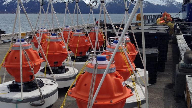
Scripps Institution of Oceanography, through a US$5.5 million grant from the US National Science Foundation (NSF), is procuring equipment to be used by the broader scientific community to study seafloor deformation. Comprising more than 50 Sonardyne Fetch subsea sensor logging nodes, this major new equipment pool will also include Sonardyne’s advanced acoustic positioning modules fitted to three Liquid Robotics Wave Gliders.
These will, for the first time, make highly precise seabed monitoring capability – at scale – available to the entire US earth science community using a technique known as GNSS-A.
Seafloor Sensors
GNSS-A combines GNSS-derived surface platform positions with acoustic ranging to seafloor sensors, enabling scientists to make centimetre-level and globally referenced measurements of movement across geological features such as subduction zones, which can cause potentially catastrophic earthquakes and tsunamis.
Unlike on land where these observations are easily acquired using the GNSS network, this scale and type of measurement have been either too costly or too impractical to acquire subsea. This has resulted in there being almost no seabed geodetic information, which has limited understanding of the geological mechanisms at work.
“This lack of seabed geodetic data has been a real challenge for scientists,” says Geraint West, global business manager oceanographic at Sonardyne. “With access to Wave Gliders, to make the highly accurate measurements to our Fetch sensors, the ability to link subsea measurements within a global reference frame is now practical and affordable. What’s more, we’re able to do this over long periods of time, taking the detailed measurements that are needed over decadal timescales.”
Robotic Platforms
“To date, only one prototype vehicle and approximately a dozen seafloor transponders have been available for the scientific community,” says David Chadwell, research geophysicist at the Marine Physics Laboratory at Scripps. “This project will provide 51 additional seafloor instruments together with 3 new robotic platforms for making the required measurements. This will approximately quintuple the equipment available to the research community to make these important measurements.
“Seafloor geodesy is poised to be transformative. It will allow for a broad community of existing and next-generation earth scientists to study active deformation on the seafloor. Improved access to these instruments will foster and communicate knowledge of the new methods and science outside of the current and very small marine community, to a much larger scientific community primarily consisting of highly-skilled land-based geodesists, and an inclusive next-generation scientific workforce.”
Image Caption: Sonardyne’s Fetch long-life subsea sensor logging nodes enable subsea to surface data acquisition over periods of up to 10 years.


