Underwater Search for Amelia Earhart’s Plane
In early July 2012, on the 75th anniversary of the disappearance of Amelia Earhart and her navigator Fred Noonan, members of Phoenix International Holdings, USA, set sail from Hawaii in support of a search effort led by The International Group for Historic Aircraft Recovery (TIGHAR). The target of the search was Amelia Earhart’s Lockheed Electra 10E aircraft. After years of research, TIGHAR theorised that the plane went down near the island of Nikumaroro, an atoll roughly 1,900 miles southwest of Hawaii. Phoenix’s role was to search one square mile of the seabed from 50 to 4,000 feet off the northwest side of the island.
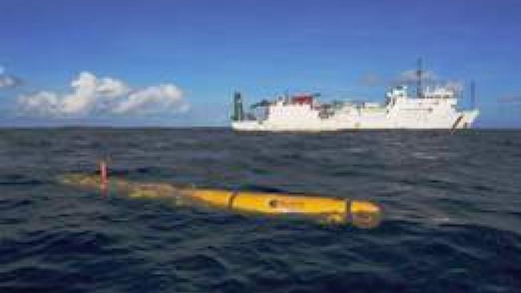
To conduct the underwater search, Phoenix deployed its new BlueFin-21 Autonomous Underwater Vehicle (AUV) and a leased Remotely Operated Vehicle (ROV) from Submersible Systems. The underwater search team consisted of five Phoenix AUV operators / ROV technicians, two BlueFin AUV technicians, and two SSI ROV technicians. After a nine-day transit aboard the research vessel Ka`imikai-o-Kanaloa (K-O-K), the team arrived at Nikumaroro and commenced undersea search operations.
During 8 days on site, the AUV spent 53 hours searching to a max depth of 4,019 feet. Search operations required the AUV to operate 15 metres off the bottom while working in and around extreme sea floor terrain that included deep crevasses and sheer cliffs. After each mission, the AUV was recovered aboard the K-O-K and data was reviewed by TIGHAR and Phoenix sonar imagery experts to identify targets for further investigation by the ROV. Despite the challenging bottom conditions, the Phoenix AUV and ROV team overcame adversity and successfully searched over 1.2 square miles of the sea floor, encompassing the entire planned search area.
Ranger 2 is the underwater target tracking system designed upon Sonardyne’s latest 6G and Wideband 2 technology platforms. The system calculates the position of a subsea target by measuring the range and bearing from a vessel-mounted transceiver to an acoustic transponder on the target, a technique known as Ultra-Short BaseLine (USBL) positioning. Multiple subsea targets over a wide area and range of water depths can be simultaneously and precisely positioned without having to deploy any additional equipment into the water. This results in fast and efficient survey operations.
This extensive underwater search provided valuable AUV sonar imagery and ROV high-definition video to support further study by TIGHAR and other forensic imaging experts –perhaps yielding more definitive clues as to the whereabouts of this famous plane.
Also see the video on the Amelia Earhart search operations.


