Wind Resource Assessment Buoy Validation
AXYS Technologies Inc announced today the deployment of the world’s first offshore wind resource assessment buoy - the WindSentinel - off Race Rocks Island in the coastal waters of British Columbia, Canada.
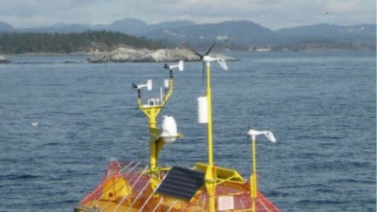
The buoy has been deployed for validation testing prior to its commercial launch. The validation tests are designed to compare wind data collected by a LIDAR on the moving buoy to wind data collected from a second, stationary LIDAR on Race Rocks Island, 0.5km away. The test site at Race Rocks Island was specifically chosen to thoroughly test the buoy's capabilities. The waters surrounding Race Rocks see currents of 5-6 knots, waves from 2 to 4m and winds up to 50 knots. The results of the study will be released to the industry in early 2010.
The WindSentinel was designed to assist offshore wind farm developers in determining the available wind resource at potential wind farm sites. It is the world's first wind resource assessment buoy capable of accurately measuring wind data at heights of conventional offshore wind turbines. Historically, wind farm developers have had to construct permanent offshore meteorological towers or 'met masts' that can cost as much as USD$10 million to build. By contrast, a basic WindSentinel costs approximately one-tenth of that amount.
"This buoy solves many of the challenges developers face when forced to use a met mast offshore," said Dennis Stacey, Renewable Energy Product Specialist at AXYS. "The WindSentinel allows developers to collect crucial wind resource assessment data more accurately, more quickly and less expensively than every other available option."
Readers can watch an online video of the WindSentinel being deployed or visit the real-time remotely controlled web camera off Race Rocks Island. For further information, visit the AXYS website .


