
This issue of Hydro International is focused on surveying the southern oceans and multibeam echosounders. You will find articles on this subject in addition to the regular columns. Do you like it better to have the magazine in your hands? Get the print edition!
In this issue:
- Interview: Dr Mathias Jonas (p. 10)
- MH370 Search Data (p. 14)
- AUSVs Accompanying the Smart Ocean Trend (p. 20)
- Planning Challenges (p. 22)
- Tidal Currents from AIS (p. 25)
Hydrography Will Be Big Contributor Filling the Digital Aquarium
 Page 10: The new Secretary-General of the International Hydrographic Organisation (IHO) Mathias Jonas has had a long career now culminating in the highest rank within the world’s leading organisation for hydrography. He took office this autumn, succeeding Robert Ward, after he was elected in spring this year by the Member States. Hydro International of course wants to know what Dr. Jonas envisions for hydrography and the wider world it influences. Mathias Jonas starts off by sharing how he was already in touch with IMO and IHO in the nineties. Read now.
MH370 Search Data
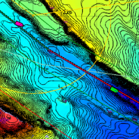
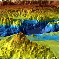 Page 14: The disappearance of Malaysian Airlines flight MH370 on 8 March 2014 led to a deep ocean search effort of unprecedented scale and detail in the remote southeastern Indian Ocean. Between June 2014 and January 2017, two mapping phases took place: (1) a shipborne bathymetric survey, and (2) a higher-resolution search in areas where accurate mapping of the seafloor was required to guide the detailed underwater search aimed at locating the aircraft wreckage. The latter phase used sidescan, multibeam and synthetic aperture sonar mounted on towed or autonomous underwater vehicles (AUVs). This article describes the mapping of the area where the aircraft was expected to be found. Read now.
Planning Challenges
 Page 22: Ninety-nine percent of international data is transmitted by around 265 subsea cable systems connecting the world. The total length of subsea cables exceeds 1.6 million kilometres, and they can be found as deep as 8,000m. The cables, which can cost hundreds of millions of dollars, must generally be run across flat surfaces of the ocean floor, taking care to avoid coral reefs, wrecks, environmentally and politically sensitive areas and general geological obstructions. Diameters are generally no thicker than an average garden hose. Cable laying is an expensive operation and is a function of the total length of cable, water depths and required protection and resulting cable types. Read now.
Tidal Currents from AIS Data
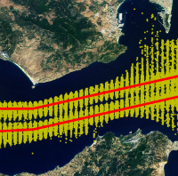 Page 25: Currents are traditionally measured with buoys and drifters, but such surveys are expensive and results are scarce. Almost all ships are equipped with an automatic identification system (AIS), primarily to improve shipping safety. Broadcast AIS signals contain information about the ship’s identity, position, speed and heading. These signals are collected at coastal stations where time stamps are added. The resulting time series make it possible to track individual ships and analyse their movements. This article shows the results of a case study in the Strait of Gibraltar making use of freely available AIS data. The method presented turns passing ships into moving buoys to obtain tidal information on surface currents. Read now.
Join Hydro International!
Follow Hydro International on Facebook, LinkedIn, Twitter or sign up for the newsletter! Don't miss the latest developments: join Hydro International!
 |  |  |  |
| 14.540 SUBSCRIBERS | 7.245 MEMBERS | 5.205 LIKES | 4.632 |