Salman Bashit
Salman Bashit, an urban planning graduate from Khulna University in Bangladesh, is currently furthering his education in Geoscience at Mississippi State University. His academic and professional journey is marked by...

Salman Bashit, an urban planning graduate from Khulna University in Bangladesh, is currently furthering his education in Geoscience at Mississippi State University. His academic and professional journey is marked by...

Oceanology International 2024 (Oi24) is set to captivate attendees with a showcase of pioneering companies and innovative technologies, all poised to command attention at London's ExCeL. From advanced autonomous vehicles...
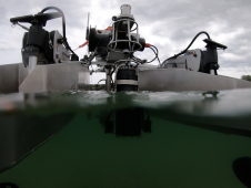
HydroSurv, a prominent provider of electric and hybrid uncrewed surface vessels (USVs), has successfully secured Innovate UK funding to advance the commercialization of an end-to-end seagrass monitoring solution. This endeavour...
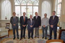
ESRI Belux has donated 50 user licenses of its ArcGIS Online to the Intergovernmental Oceanographic Commission (IOC) Project Office for International Oceanographic Data Exchange (IODE), Ostend, Belgium. To mark the...
Esri has expanded its mobile geographic information system (GIS) platform to now support the iPhone, iPad, and iPod touch. The new ArcGIS for iOS includes both a free downloadable application...
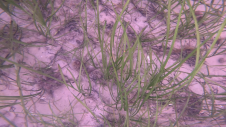
Seagrass meadows play an invaluable role as critical ecosystems that contribute significantly to marine biodiversity, carbon sequestration and coastal protection. In recent years, the importance of these underwater habitats has...
Esri Ocean Basemap has released a new World Ocean Basemap. This release reflects a major change to the structure of the basemap, as the World Ocean Basemap now consists of...
Whenever new objects have to be created, be it on or below the land and water, construction plays a role. The construction process often starts with surveying, either [marine surveying]...
The new version of ArcGIS Explorer, a free geographic information system (GIS) viewer, opens more avenues for users to share geographic information. It also has new interoperability updates that help...
Esri is offering a free, one-day seminar, Increase Productivity with ArcGIS 10, that will benefit professionals in all industries, whether they are working in a desktop, mobile, server, or cloud...
This site uses cookies. By continuing to use this website, you agree to our Cookies Policy. Agree