Data is here to stay
While online data acquisition is of course of the utmost importance in hydrography, technological developments mean that modern surveyors also need to know about data science, machine learning and artificial...
While online data acquisition is of course of the utmost importance in hydrography, technological developments mean that modern surveyors also need to know about data science, machine learning and artificial...

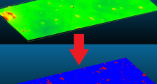
OceanWise has announced that, as of 1 November 2021, the RSOBIA toolbar is available free of charge. The software tool, which takes raster imagery and segments the data into geographic...
Cartography is about describing the world in the form of maps and diagrams. Classic cartography produces paper maps but nowadays this field also encompasses Geographical Information Systems and the products...
Teledyne Optech and Teledyne CARIS have united to form Teledyne Geospatial in response to evolving marketplace needs. Under the Teledyne Imaging group, the harmony between the two business units is...
TCarta Marine, a global provider of hydrospatial products, will demonstrate the new Trident Satellite Derived Bathymetry (SDB) Toolbox, now available as a software-as-a-service product, at GEOINT 2021, which is being...
Teledyne has announced the launch of a geospatial group with the unification of its Optech and CARIS businesses. The new Teledyne Geospatial group will offer holistic solutions to seamlessly map...
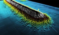
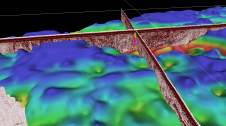
The combination of bathymetry and Lidar provides in-depth data and view of stream quality for aquatic resource managers in Tennessee, USA. Since its inception in 2015, Skytec has created data-driven...
In 2021, five Norwegian and international companies decided to join forces to support the development of software that can be used to interpret seabed and subsurface ground conditions and visualize the results. The...
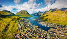
Crewless aerial mapping was recently chosen when surveying the Faroe Islands. For the small team, labour savings provided one advantage of a UAV-based approach. Another benefit was that clear skies...
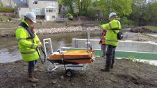
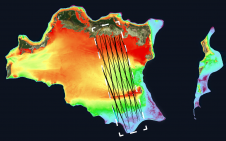
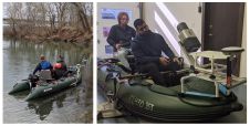
In early spring 2021, Storm Geomatics were approached by an existing client to carry out topographic and bathymetric surveys on the River Aire, in the village of Newlay, to the...
This site uses cookies. By continuing to use this website, you agree to our Cookies Policy. Agree