The challenges of surveying the Faroe Islands
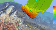
Crewless aerial mapping was recently chosen when surveying the Faroe Islands. For the small team, labour savings provided one advantage of a UAV-based approach. Another benefit was that clear skies...
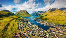
Crewless aerial mapping was recently chosen when surveying the Faroe Islands. For the small team, labour savings provided one advantage of a UAV-based approach. Another benefit was that clear skies...
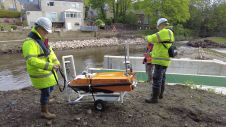
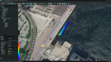
In early spring 2021, Storm Geomatics were approached by an existing client to carry out topographic and bathymetric surveys on the River Aire, in the village of Newlay, to the...
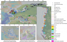
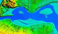
EMODnet Geology has updated the ‘Submerged Landscapes’ data product. This fully attributed GIS layer now comprises more than 16,000 features representing 27 classes of submerged landscape and palaeoenvironmental indicators, including...

Dr Gema Casal holds a degree in marine biology and a PhD on coastal remote sensing and GIS. She is interested in the application of remote sensing technologies, especially optical...
In this maritime webinar, attendees will learn how to use ArcGIS automated workflows and machine learning techniques for coastline extraction.
As the demand for elevation data continues to rise, it is important that users match the level of reliability, accuracy and resolution of the data to their specific application to...
XOCEAN has completed 35 cable inspection surveys using a combination of uncrewed surface vessels (USVs) and uncrewed aerial vehicles (UAVs) between the Scottish mainland and Western Isles. There was a...
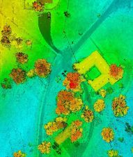
Archaeologists have long been interested in shipwrecks. These sites can tell us about ancient transportation and trading routes, technological innovations and cultural exchanges over thousands of years. Documenting shipwrecks can...
EIVA’s software combination, NaviEdit and NaviModel, has undergone a significant upgrade. NaviEdit is the company’s software tool for editing survey data, while NaviModel enables the creation of high-performance digital terrain...
Bluesky International will use aircraft-mounted Lidar sensors to create a highly detailed 3D map of the whole of the Northern Ireland coastline. The Bluesky data will form part of the...
This site uses cookies. By continuing to use this website, you agree to our Cookies Policy. Agree