The Titanic disaster and its aftermath
In the night of 14 April 1912, the unthinkable happened. The mightiest ship afloat, the brand new White Star Line ship Titanic, was on its maiden voyage from Southampton, England,...
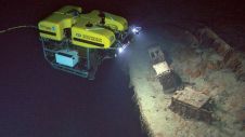
In the night of 14 April 1912, the unthinkable happened. The mightiest ship afloat, the brand new White Star Line ship Titanic, was on its maiden voyage from Southampton, England,...

Hydro International spoke to five leading experts about the present and future of the hydrographic industry. In this interview, Birte Noer Borrevik (Kartverket: the Norwegian Mapping Authority) talks about big...

Mathias Jonas, Secretary-General of the International Hydrographic Organization (IHO), was forced to ponder on the term ‘hydrospatial’ and its place in the language of the hydrographic community. During a panel discussion...
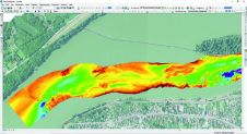
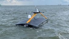
A new survey vessel named Garda, equipped with a multibeam echosounder, has been acquired as part of the FAIRway Danube project. Through the project, a new dedicated survey crew has...
Ready to invest, in equipment, staff and training, but unsure about future growth at this stage of the Covid-19 pandemic: that seems to be the outcome of our Hydro International...

Rachel Bobich is a hydrographer and the proprietor of RMB GEO, a marine and data science firm. She specializes in hydrospatial mapping techniques such as topobathy Lidar and satellite-derived bathymetry,...

CHC Navigation at a glance CHC Navigation (CHCNAV) is a publicly listed company creating innovative GNSS navigation and positioning solutions. With a global presence across the world and distributors in...
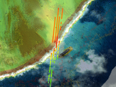
TCarta Marine has announced the development of new machine learning-based bathymetric mapping technologies – including the creation of two software packages and the commercial application of NASA’s ICESat-2 satellite –...
Hydrographic offices (HOs) today exist in a world of accelerating technological change that is influencing human behaviour and creating new needs for and ways of exploiting data to understand our...

Joseph Avis received his BSc in Physical Geography before completing his MSc in Remote Sensing and GIS at Aberystwyth University, Wales, UK, in 2017 and 2018 respectively. His MSc thesis...
This site uses cookies. By continuing to use this website, you agree to our Cookies Policy. Agree