High Precision Positioning
The port of Monaco is undergoing an extensive construction process that will help double the port's capacity and protect it from heavy eastern swells and dangerous Mediterranean storms. The new...
The port of Monaco is undergoing an extensive construction process that will help double the port's capacity and protect it from heavy eastern swells and dangerous Mediterranean storms. The new...
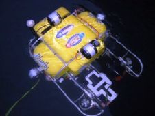
The AUV Fest, held July 2007 and sponsored by the Office of Naval Research, staged Bluefin Robotic's most recent vehicle capabilities. During the two-week long demonstration of autonomous underwater vehicles...
Hydrography is to many in our profession an unfamiliar word. When in my early days explaining what my job comprised I used to extrapolate it from ‘hydro’ and ‘graphy’, the...
It is clear Geographical Information Systems (GIS) are providing added value business solutions in the wider geomatics world; this may be seen reading the many articles in the Geomatics Information...
Surveying is benefiting from continually evolving new technologies. One is 3D laser scanning, which is often used for measurements in complex industrial installations such as pipeline-rack crossings or entire petrochemical...
Safe Software announced a joint agreement with Oregon-based TCI Software. The agreement will see TCI's Curvefitter linear optimisation technology integrated into the upcoming release of FME 2007, providing users with...
Oil and gas fields in the North Sea and elsewhere in the western world developed rapidly during the oil crisis of the seventies, when this commodity quadrupled in price. Now...
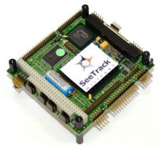
SeeByte has received an order of additional Autonomous Underwater Vehicle (AUV) sidescan embedded mine Computer Aided Detection and Classification (CAD/CAC) system to the Royal New Zealand Navy (RNZN). SeeByte’s SeeTrack...
Safe Software has granted official "FME Certified" accreditation to FME experts from around the world. These individuals are the first to be formally assessed and recognised as part of a...
Safe Softwar's FME spatial ETL (extract, transform, and load) platform will support the spatial data capabilities made available in the SQL Server 2008 November Community Technology Preview (CTP). In the...
This site uses cookies. By continuing to use this website, you agree to our Cookies Policy. Agree