Wreck Monitoring in Dredging Operations
The problems posed by the wrecked vessel Assi Eurolink called for unique solutions that have set a new benchmark in the way that similar wrecks are made safe. On 25th...
The problems posed by the wrecked vessel Assi Eurolink called for unique solutions that have set a new benchmark in the way that similar wrecks are made safe. On 25th...
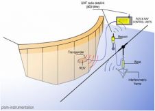
An USBL underwater positioning system is the ideal solution for dam survey by ROV, providing easy and fast set-up and accurate 3D measurement for traceability, but not all USBL systems...
To support the production and maintenance of navigational charts, the United Kingdom Hydrographic Office (UKHO) receives large quantities of bathymetric data from a great number of sources. This data is...
Nova Scotia is one step closer to building North America's first in-stream tidal technology centre to host some of the world's leading devices to harness energy from the world's highest...
Safe Software has released FME 2008. The release includes the unveiling of FME Server, a scalable solution for data transformation and distribution, as well as a new version of FME...
An alliance between Carlson Software Inc. and HydroCAD Software Solutions, LLC, was revealed at the Carlson Silver Anniversary User Conference, held 14 and 15 April in Lexington (KY, USA). HydroCAD...
Spool and jumper metrologies constitute a critical path in the subsea pipe installation process. They can often occupy large construction vessels ‘just’ for survey operations that may last more than...
The Canadian Hydrographic Association was created by a number of senior people in the Canadian Hydrographic Service in 1966/1967 in answer to a requirement for hydrographic training and professional status...
SeeByte has been awarded a twelve month contract extension through the Office of Naval Research (ONR). PATT is a Performance Analysis & Training Tool developed by SeeByte which can be...
Applied Signal Technology has chosen the MacArtney A/S Focus-2 ROTV as platform for the fastest, most accurate towed SAS (synthetic aperture sonar) system yet - the Prosas Surveyor. This towed...
This site uses cookies. By continuing to use this website, you agree to our Cookies Policy. Agree