Naval National Protection Initiatives Support
The Mexican Navy is now using ERDAS APOLLO to manage and serve geospatial imagery and data in support of its national protection initiatives. The Mexican Navy imagery warehouse includes hundreds...
The Mexican Navy is now using ERDAS APOLLO to manage and serve geospatial imagery and data in support of its national protection initiatives. The Mexican Navy imagery warehouse includes hundreds...
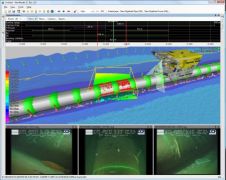
As part of a European Project to develop new underwater non-destructive testing (NDT) tools, Fugro GRL provided its DeepWorks software to simulate the deployment by ROV of a long range...
A recent order placed by Nautikaris, Netherlands, completes a trio of Coda Echoscope purchases by some of CodaOctopus' key international distributors. As well as Cadden (France) and Sea and Land...
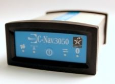
C-Nav, vendor of GNSS Precise Point Positioning (PPP) services, has announced the launch of its new Dynamic Position aiding software, C-Scape. C-Scape is a Windows application designed to provide independent...

Sensor Technology Ltd is a vertically integrated component manufacturer that produces piezoelectric ceramics and piezo-based acoustic transducers. Located in Collingwood, near Toronto, Canada, the company has grown steadily for nearly...
MariSoft, Egypt, has made integrated software sales to subsea cable specialists, Offshore Marine Management's (OMM) survey services section. OMM has utilised Inspector and HydroChart on all their projects to date...
Bowtech Products Ltd has started working from its new 2,500sq ft Subsea Moulding Facility on the Kirkhill Industrial Estate in Aberdeen, UK. Bowtech Products represent Seacon Europe for the complete...
On 6 July 2010, Hexagon AB entered into an agreement to acquire US-based software provider Intergraph Corporation. The transaction, at a value of USD2,125 million, is financed on cash basis....
This is the continuation of the Oceanology International Preview. For companies A - L, see part 1 MacArtney Underwater Technology Group MacArtney will be introducing their newest innovation in multiplexers...
NaviModel software for ocean mapping, data analysis and interpretation provides intuitive 3D visualiasation of infinite survey data sets by import of multiple data formats and sources using user-defined templates. NaviModel...
This site uses cookies. By continuing to use this website, you agree to our Cookies Policy. Agree