Extreme Swath Survey: The Dead Sea
A future article in Hydro international will describe our recent multi-beam survey of the Dead Sea. This brief overview extols the virtues of renting a complete multi-beam system as opposed...
A future article in Hydro international will describe our recent multi-beam survey of the Dead Sea. This brief overview extols the virtues of renting a complete multi-beam system as opposed...
Narrow tidal channels often provide challenges to shipping. Reliable charting of tidal-stream flow is important for safety. Acoustic Doppler current-profiler (ADCP) survey is now a commonplace method of charting tidal...
The North Sea directorate of the Ministry of Public Works and the department of Geo-Marine & Coast of The Netherlands Institute of Applied Geoscience-TNO jointly carried out a geological mapping...
Nearshore engineering surveys are undertaken for the purpose of gathering information pertaining to the bathymetry and morphology of the seabed, along with the geotechnical characteristics and geophysical profiles of the...
IXSEA has signed a deal with the Canadian Scientific Submersible Facility (CSSF) for a Global Acoustic Positioning System (GAPS), a number of transponders along with spare parts. GAPS is a...
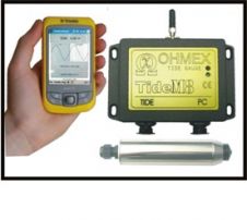
TideM8 is a combination of the Ohmex TideM8 miniature tide gauge system and Trimble's Juno hand-held Mobile PC with integrated GPS. The system is a new design based on the...
When Oi08 opens at the ExCeL centre in London’s Docklands on 11 March, the exhibition and its accompanying conference will focus on the three important issues that have begun to...
IXSEA has presented its new range at EURONAVAL in Paris, Le Bourget from 23 to 27 October 2006. The company has launched, MANTTAS, a mobile, adaptative network designed for torpedo...
There were three major overlapping phases in Mike Eaton’s career: Arctic developments in the Canadian Hydrographic Service, positioning systems development while at the Bedford Institute and electronic chart development after...
De Beers Marine routinely acquires ultra high-resolution geophysical data in support of its offshore mining and exploration programmes for diamondiferous placer deposits situated on the continental shelf off the West...
This site uses cookies. By continuing to use this website, you agree to our Cookies Policy. Agree