Introducing the Denmark Depth Model
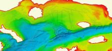
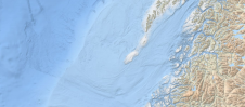
The Denmark Depth Model (DDM) is a digital bathymetric model covering Denmark’s exclusive economic zone (EEZ). It was developed based on hundreds of bathymetric survey datasets and historical sources and...
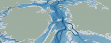
The Denmark Depth Model (DDM) is a digital bathymetric model covering Denmark’s exclusive economic zone (EEZ). It was developed based on hundreds of bathymetric survey datasets and historical sources and...
When looking to buy hydrographic processing software, it is important to establish the requirements in order to find the best software for the job at hand. The users’ technical skills,...
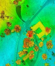
Arctia-Meritaito has efficiently produced a seamless digital terrain model of land and water along the shallow coastal areas of the German island of Sylt, using a Leica Chiroptera 4X airborne...
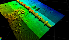
XOCEAN has completed 35 cable inspection surveys using a combination of uncrewed surface vessels (USVs) and uncrewed aerial vehicles (UAVs) between the Scottish mainland and Western Isles. There was a...
As the demand for elevation data continues to rise, it is important that users match the level of reliability, accuracy and resolution of the data to their specific application to...
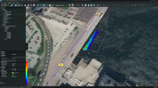
EIVA’s software combination, NaviEdit and NaviModel, has undergone a significant upgrade. NaviEdit is the company’s software tool for editing survey data, while NaviModel enables the creation of high-performance digital terrain...
EMODnet Bathymetry, an initiative of the European Commission, has announced on behalf of the full consortium with all associated collaborators the release of the latest version of the EMODnet Bathymetry...
Hydrographers and data processors are expected to produce high-quality deliverables with a swift turnaround in this present age of data collection and technological refinement. However, the cost of proprietary commercial...
Bathymetry, the topography of the seafloor, is a fundamental feature of the ocean. Accurate bathymetric data is the foundation for much of ocean science and policy. For example, nautical charts...
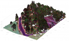
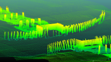
The arrival of airborne Lidar, also referred to as airborne laser scanning (ALS), has revolutionized area-wide 3D data acquisition of topography, bathymetry, vegetation, buildings and infrastructure. This article presents an...
This site uses cookies. By continuing to use this website, you agree to our Cookies Policy. Agree