Found 75 results
Sort by

The Art of Bathymetry

Great advancements have been made in three dimensional printing over the last few years and have made an impressionable impact across a variety of industries. 3D printings’ versatility can be...

Read more

New NaviModel Software Generation

NaviModel 4 by EIVA, Denmark, includes a free viewer, the completion of laser scanner data implementation throughout the data acquisition and processing workflow covered by the EIVA NaviSuite products, and...

Read more

Raw Data as Information Source

For hydro- and topographic surveying companies it is common to gather data in the field and process it into formats for presentation. Nowadays, technology  provides more and more solutions that...

Read more

Introducing GIS to Support Maritime Accessibility

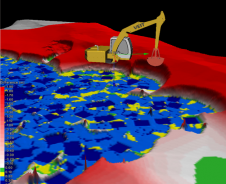
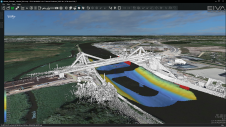
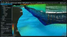
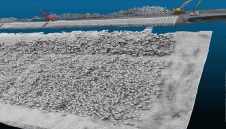
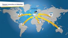
The Port of Rotterdam is Europe’s largest port and is one of the world’s key logistic hubs. Hydrographic data is critical to the Harbour master’s department for the operation of the Port of Rotterdam, to support the nautical accessibility of the deep-sea vessels by electronic nautical chart. The introduction of PortMaps enables the Port of Rotterdam to produce a wide variety of information products, including ENCs, from the Port’s survey data, in less than 48 hours. With over 500 line connections to and from more than 1,000 ports around the globe, the Port of Rotterdam in The Netherlands is the cornerstone of international freight transport. It is the...

Read more

Mapping Liquid Water on Mars

To tie in with NASA’s recent announcement about the discovery of liquid water on Mars, Esri has put together an interactive story map showing the craters and canyons on Mars that...

Read more