GEBCO and Deep Water
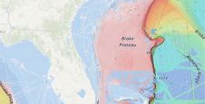
GEBCO uses deepwater survey data to produce bathymetry maps and grids. Published maps appear complete but are in fact based on very little data. Only a portion of the deep...
GEBCO uses deepwater survey data to produce bathymetry maps and grids. Published maps appear complete but are in fact based on very little data. Only a portion of the deep...
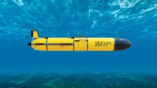
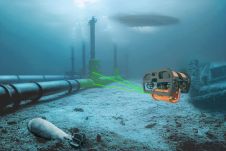
Teledyne Webb Research, a leading innovator in oceanographic research, has launched the Slocum Sentinel Glider, poised to make its debut at Oceanology International (Oi) in London in March 2024. The...
A 120-year-old mystery has been solved with the help of a CSIRO team aboard the RV Investigator. Heritage NSW has announced the discovery of the SS Nemesis, a 73-metre iron-hulled...

IIT Madras has established a Centre of Excellence (CoE) dedicated to advancing indigenous maritime technology and expertise. The team of researchers leading this initiative has been actively engaged in notable...

IHO standard S-44 is often used (or misused) to specify the quality of a hydrographic survey. While it is a useful tool, it is easy to misinterpret. One ‘misuse’ is...
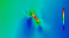
Restricted operating life, limited range and bearing ambiguity in deep water are the known limitations of current locator beacons mounted on aircraft. These problems raise important questions: what is the...
A groundbreaking study has unveiled the discovery of an immense coral reef on the bottom of the Atlantic Ocean, marking the largest deep-sea coral reef ever measured. Spanning approximately 26,000...
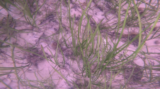
Seagrass meadows play an invaluable role as critical ecosystems that contribute significantly to marine biodiversity, carbon sequestration and coastal protection. In recent years, the importance of these underwater habitats has...
The esteemed Finnish Geospatial Research Institute (FGI) is set to utilize advanced Lidar systems developed by the Fraunhofer Institute for Physical Measurement Techniques IPM for future maritime surface surveys. Anticipating...
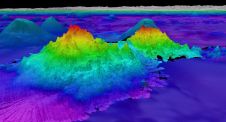
The crew of Schmidt Ocean Institute’s research vessel Falkor (too) recently discovered four underwater mountains – the tallest of which exceeds 2.4km in height – during a January transit from...
This site uses cookies. By continuing to use this website, you agree to our Cookies Policy. Agree