GEBCO and Deep Water
GEBCO uses deepwater survey data to produce bathymetry maps and grids. Published maps appear complete but are in fact based on very little data. Only a portion of the deep...
GEBCO uses deepwater survey data to produce bathymetry maps and grids. Published maps appear complete but are in fact based on very little data. Only a portion of the deep...
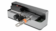
EM 2042 Multibeam Echosounder Small in size, but powerful in potential, the EM 2042 Multibeam Echosounder is efficient, light, robust and reliable: delivering high-density, high-resolution, clean data in the most demanding marine environments. With...
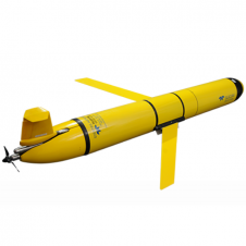
The Slocum glider is buoyancy-driven to enable long-range and duration remote water column observation for academic, military, and commercial applications. It can be deployed and recovered from any size vessel with minimal time on station The Slocum glider is buoyancy driven to enable long range and duration remote water column observation for academic, military, and commercial applications. The Slocum Glider can be deployed and recovered...
RIEGL has announced the launch of two innovative topobathymetric scanners. These advancements mark a shift towards enhanced efficiency and precision in data collection across land and water interfaces. The RIEGL...
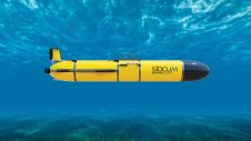
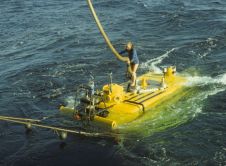
Teledyne Webb Research, a leading innovator in oceanographic research, has launched the Slocum Sentinel Glider, poised to make its debut at Oceanology International (Oi) in London in March 2024. The...
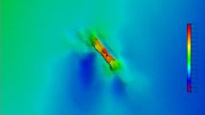
A 120-year-old mystery has been solved with the help of a CSIRO team aboard the RV Investigator. Heritage NSW has announced the discovery of the SS Nemesis, a 73-metre iron-hulled...

IIT Madras has established a Centre of Excellence (CoE) dedicated to advancing indigenous maritime technology and expertise. The team of researchers leading this initiative has been actively engaged in notable...
Restricted operating life, limited range and bearing ambiguity in deep water are the known limitations of current locator beacons mounted on aircraft. These problems raise important questions: what is the...

IHO standard S-44 is often used (or misused) to specify the quality of a hydrographic survey. While it is a useful tool, it is easy to misinterpret. One ‘misuse’ is...
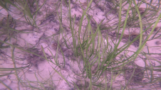
Seagrass meadows play an invaluable role as critical ecosystems that contribute significantly to marine biodiversity, carbon sequestration and coastal protection. In recent years, the importance of these underwater habitats has...
This site uses cookies. By continuing to use this website, you agree to our Cookies Policy. Agree