The New IHO S-102 Standard
Soundings and contours are the only official way data producers can push bathymetric information to the wide hydrographic community. The introduction of the S-102 standard for bathymetry will enable many...
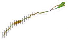
Soundings and contours are the only official way data producers can push bathymetric information to the wide hydrographic community. The introduction of the S-102 standard for bathymetry will enable many...

Hydrographers need to step up and fill the I in ECDIS, says Michael Casey, vice president Geospatial Systems at IIC Technologies and prior to that director for Nautical Charting at...
ECDIS Ltd have opened their new eNavigation Centre at Solent Business Park, where they will deliver their MCA accredited IMO 1.27 Model ECDIS course. The centre is equipped with full...
Adam Weintrit, Dean of the department of Navigation of Gdynia Maritime University (Poland), has written a handbook on Electronic Chart Display and Information Systems, aiming to provide answers to some...
On 6–7 February 2008, the members of the HSR took part in the all-Russian scientific-technical seminar with the theme ‘The Modern Condition of Electronic Cartography for Sea and River Navigation’....
Italy is the first nation officially to adopt ECS systems - other than ECDIS - as equivalent standard to paper charts. The approved ECS systems, as defined by issued standard,...
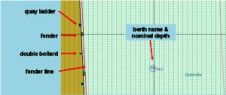
The management of larger vessels within the confined, shallow and/or tidal environments of ports requires precise chart information. However, current ECDIS and Inland ECDIS standards do not meet the more...
The bathymetric ENC (bENC) concept was developed by SevenCs several years ago and was presented in the September 2005 issue of Hydro International, ‘Ports and Harbours Special’. The approach aims...
An electronic chart system, whether an Electronic Chart Display and Information System (ECDIS) or an Electronic Chart System (ECS), is primarily designed for safe navigation. But its ability to display...
News Workshop Harbour Approach The HSB will organise a workshop on harbour approach, to be held in Ostend, Belgium, on Friday 29th November 2002. The preliminary programme for the workshop...
This site uses cookies. By continuing to use this website, you agree to our Cookies Policy. Agree