ENC Tools User Conference
SevenCs' second user conference will be on 1st November 2010 in Rostock, Germany, just before Hydro 2010. The one-day conference will feature guest speakers, hands-on seminars, and the opportunity to...
SevenCs' second user conference will be on 1st November 2010 in Rostock, Germany, just before Hydro 2010. The one-day conference will feature guest speakers, hands-on seminars, and the opportunity to...
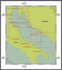
From the quality perspective, an electronic navigational chart (ENC) as a product is more demanding than its paper predecessor. Quality control and quality assurance of an ENC is a complex...

Jeppesen Marine has launched Jeppesen PRIMAR ENC Service, which effectively combines two services into a single offering that ensures mariners easy access to charts, from the Norwegian provider of marine...
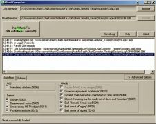
The Chart Corrector has been created as a tool to assist the routine operations in the process of IHO S-57 ENC creation/correction. The authors considered all possible requirements of national...
ECDIS has been standardised by the IHO in Special Publications No. 57 (S57) and No. 52 (S52) and is established in coastal and open sea areas. The S57 standard covers...
Two electronic charting services developed by the UK Hydrographic Office (UKHO) will beunveiled at the Europort Maritime exhibition. The services will further strengthen UKHO's commitment to the Safety Of Life...
SevenCs and HSA have released of the latest version of ENC Analyzer. ENC Analyzer now checks edition 3.0 of the IHO’s recommended ENC validation checks, S-58, released February 2007, the...
Imagine piloting a 398m container ship into port TODAY using an ENC updated with survey data collected YESTERDAY. Isn’t this order of turnaround time the ultimate dream of any ENC...
SevenCs launched ENC Watermarker, which aims to protect intellectual properties. This application prevents piracy of a complete ENC data set or single cells. ENC Watermarker generates a replacement data set...
Updated Norwegian electronic navigational chart (ENC) data can now be downloaded and used in the open-source chart plotter and navigation software, OpenCPN. The Norwegian Mapping Authority Hydrographic Service's electronic navigational...
This site uses cookies. By continuing to use this website, you agree to our Cookies Policy. Agree