The evolution of Dutch hydrography
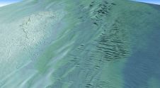
Given the Netherlands’ geographical location, it is unsurprising to find it has a long tradition of hydrography. The lowland, often below sea level, forms a delta where major rivers from...

Given the Netherlands’ geographical location, it is unsurprising to find it has a long tradition of hydrography. The lowland, often below sea level, forms a delta where major rivers from...

Hydromea, a pioneering leader in subsea technology, has announced a significant advancement in underwater propulsion with the successful completion of a demanding pressure test on its deep-rated ultra-thin Diskdrive thrusters....

A consortium of USV and hydroacoustic tech firms, including ACUA Ocean, GeoAcoustics and Unmanned Survey Solutions (USS), has secured funding from the British Department for Environment, Food and Rural Affairs...

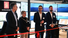
Ocean surveying and inspection specialist Argeo Subsea, CSI Nordics and Kongsberg Discovery have formalized a three-party Certificate of Delivery and Acceptance for an advanced HUGIN Superior AUV. This milestone agreement,...

Geospatial cloud specialist north.io has announced it aims to revolutionize the modelling, collection and processing of ocean data using NVIDIA technologies. According to Jann Wendt, CEO, north.io, the synergy between...
Teledyne Geospatial has announced that Tetra Tech, a leading provider of high-end consulting and engineering services, recently acquired a Teledyne Optech CZMIL SuperNova Topobathymetric Lidar system. Tetra Tech has successfully...
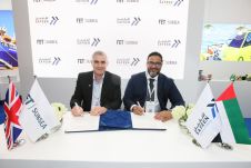
Forum Energy Technologies (FET) has announced that its Subsea Technologies product line executed a memorandum of understanding with an underwater inspections provider, Safeen Survey & Subsea Services, to collaborate on...

Narcisa Pricope is an associate vice president for research in the Office of Research and Economic Development at Mississippi State University and a professor in the Department of Geosciences. Prior...
Autonomous vessel operations company Massterly has opened its Remote Operations Centre (ROC) in Horten, Norway. This significant step marks a crucial transition from the testing phase to fully-fledged operational capabilities...

In the quest to unravel the mysteries beneath our planet’s water bodies, topobathymetric technologies emerge as a beacon of innovation. Among them, Lidar (light detection and ranging) and sonar sensors...
This site uses cookies. By continuing to use this website, you agree to our Cookies Policy. Agree