Les Ford as Consultant at EdgeTech
EdgeTech, USA, has hired marine industry expert Les Ford in a consultancy role with the company. With over 30 years in the industry, Mr Ford has extensive operational and managerial...

EdgeTech, USA, has hired marine industry expert Les Ford in a consultancy role with the company. With over 30 years in the industry, Mr Ford has extensive operational and managerial...
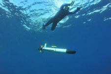
OceanServer Technology, USA, continues to deliver superior AUV-based acoustic imaging with the qualification and release of the new EdgeTech 2205 high-resolution side-scan sonar. The 2205, designed specifically for use on...
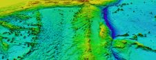
ARGANS, a leading Earth observation company, has contributed a significant dataset of 8,000 square kilometres to The Nippon Foundation-GEBCO Seabed 2030 Project – the project seeking to inspire the complete...

Various attempts have recently been made to expand the scope of research in the maritime field through the convergence of cutting-edge technologies. One example is the remote classification and prediction...
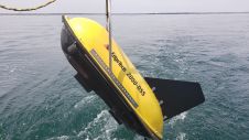
EdgeTech – a leading company in high-resolution sonar imaging systems and underwater technology – has recently introduced an innovative and new method to provide nadir gap coverage on the EdgeTech...
An EdgeTech 4200-FSL Side Scan Sonar System has been installed on a Sea Robotics USV (Unmanned Surface Vehicle) -5000, purchased by David Evans and Associates, Inc. for use on contracts...
EdgeTech, one of the leading companies in high-resolution sonar imaging systems and underwater technology, has recently introduced a new combined tri-frequency sidescan sonar and high-resolution sub-bottom profiling sonar system. The...
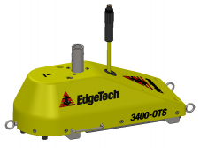
EdgeTech, a leading company in high-resolution sonar imaging systems and underwater technology, has recently introduced two new pole-mount sub-bottom profilers to the family of 3400 sub-bottom profiling systems. Building on...

The Offshore Energy Exhibition & Conference 2023 (OEEC 2023) has concluded its two-day extravaganza, leaving an indelible mark on the offshore energy industry. Against a backdrop of innovation and collaboration,...

Teledyne Geospatial has announced that CARIS software, globally preferred by national mapping and charting agencies, survey companies, port and waterway authorities, oil and gas companies and academic institutions, will now...
This site uses cookies. By continuing to use this website, you agree to our Cookies Policy. Agree