The evolution of Dutch hydrography
Given the Netherlands’ geographical location, it is unsurprising to find it has a long tradition of hydrography. The lowland, often below sea level, forms a delta where major rivers from...

Given the Netherlands’ geographical location, it is unsurprising to find it has a long tradition of hydrography. The lowland, often below sea level, forms a delta where major rivers from...

Fujitsu has presented a pioneering technology that harnesses Lidar and AI to capture high-resolution 3D data of organisms, coral reefs and man-made structures such as offshore wind turbines using autonomous...

A consortium of USV and hydroacoustic tech firms, including ACUA Ocean, GeoAcoustics and Unmanned Survey Solutions (USS), has secured funding from the British Department for Environment, Food and Rural Affairs...

An international expedition to the Salas y Gómez Ridge has uncovered 160 species, potentially including 50 new to science. Led by Dr Erin E. Easton and Dr Javier Sellanes, the...

Ocean surveying and inspection specialist Argeo Subsea, CSI Nordics and Kongsberg Discovery have formalized a three-party Certificate of Delivery and Acceptance for an advanced HUGIN Superior AUV. This milestone agreement,...

Between January 2023 and February 2024, TDI-Brooks, a specialized company in geotechnical and offshore survey projects, conducted an extensive site investigation programme across two offshore wind blocks in state and...

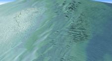
By harnessing capabilities of advanced satellite technology and ever-evolving data analysis, satellite-based mapping (including satellite-derived bathymetry, SDB) offers an efficient, extensible and cost-effective method for mapping water properties, underwater topography...

Kongsberg Discovery commemorates 30 years of inertial navigation excellence with the launch of Seapath 385. Unveiled at Oceanology International in London, this innovative system integrates new hardware and advanced navigation...
Kongsberg Discovery, a leading player in oceanographic instrumentation, has introduced a new product innovation to the ADCP market, blending “flexibility, simplicity and high-resolution performance.” Unveiled at Oceanology International, the CP333...
Teledyne Geospatial has announced that Tetra Tech, a leading provider of high-end consulting and engineering services, recently acquired a Teledyne Optech CZMIL SuperNova Topobathymetric Lidar system. Tetra Tech has successfully...
This site uses cookies. By continuing to use this website, you agree to our Cookies Policy. Agree