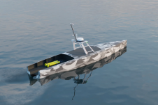
Found 2327 results
Sort by

Lidar in surveying & mapping

Lidar, short for Light Detection and Ranging surveying, represents a sophisticated measuring system leveraging the power of light. Widely recognized for its versatility, Lidar is extensively applied in diverse fields...

Read more

Mapping Underwater Habitat

Biosonics’ Visual Habitat DT-X is a software product for the rapid assessment and mapping of aquatic habitat features. With Visual Habitat software, users can present information in a clear and...

Read more

Benthic Habitat Mapping

The establishment of multi-beam echo sounders (MBES) as a mainstream tool in ocean mapping has revolutionised approaches towards nautical charting, seafloor geotechnical/geological surveys and benthic habitat mapping. The resolution of...

Read more