Giant coral reef discovered on Atlantic seabed
A groundbreaking study has unveiled the discovery of an immense coral reef on the bottom of the Atlantic Ocean, marking the largest deep-sea coral reef ever measured. Spanning approximately 26,000...
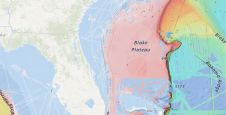
A groundbreaking study has unveiled the discovery of an immense coral reef on the bottom of the Atlantic Ocean, marking the largest deep-sea coral reef ever measured. Spanning approximately 26,000...
The esteemed Finnish Geospatial Research Institute (FGI) is set to utilize advanced Lidar systems developed by the Fraunhofer Institute for Physical Measurement Techniques IPM for future maritime surface surveys. Anticipating...
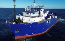
TDI-Brooks has strengthened its fleet with the RV Nautilus, a 75-metre DP2 vessel with enhanced capabilities that was built in 2000. This addition, which features the Geomil Manta-200 CPT system...
Lidar, short for Light Detection and Ranging surveying, represents a sophisticated measuring system leveraging the power of light. Widely recognized for its versatility, Lidar is extensively applied in diverse fields...
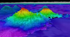
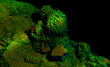
The crew of Schmidt Ocean Institute’s research vessel Falkor (too) recently discovered four underwater mountains – the tallest of which exceeds 2.4km in height – during a January transit from...
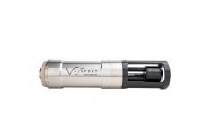
The new SWiFT Deep CTD is the latest in Valeport’s popular range of SWiFT profilers and delivers enhanced accuracy and versatility for those requiring CTD measurements to depths of 6000m. The new SWiFT Deep CTD profiler provides survey-grade sensor technology coupled with the convenience of Bluetooth® wireless technology, a rechargeable battery and an integral GPS module to geo-locate each profile. Ease of...

With innovation, progress and discovery at its heart, Oceanology International 2024 (Oi24) is preparing to welcome the world’s largest gathering of ocean professionals to the most powerful and inspirational event...
Voyis, a pioneer in optical solutions for subsea vehicles, has announced its work with Memorial University of Newfoundland on an extraordinary scientific expedition to the Galápagos Islands, funded by Schmidt...

Rijkswaterstaat, part of the Dutch Ministry of Infrastructure and Water Management, is responsible for managing and maintaining the main infrastructure facilities in the Netherlands. As part of its efforts to...
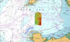
The UK Hydrographic Office (UKHO) has supported a greater understanding of the Irish Sea’s geological history, after analysing seabed mapping data collected under the Civil Hydrography Programme (CHP) to support...
This site uses cookies. By continuing to use this website, you agree to our Cookies Policy. Agree