Anders Ekelund
Anders Ekelund is vice president airborne bathymetric Lidar at Hexagon’s Geosystems division. In this role, he is responsible for developing competitive solutions and services for customers in the bathymetric industry....
Anders Ekelund is vice president airborne bathymetric Lidar at Hexagon’s Geosystems division. In this role, he is responsible for developing competitive solutions and services for customers in the bathymetric industry....
As part of a Catalan government project to improve the management of its marine environment, ICGC cooperated with Field to use airborne Lidar bathymetry (ALB) to survey the Catalan coastal...
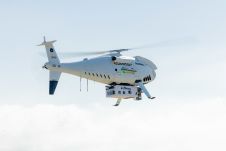
Fugro recently introduced its next-generation coastal mapping system, the Rapid Airborne Multibeam Mapping System (RAMMS 2.0), at the Hydro 2023 conference in Genoa, Italy. RAMMS 2.0, the world’s only airborne...
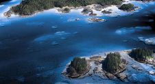
The National Oceanic and Atmospheric Administration (NOAA) contracted NV5 Geospatial to define the shoreline in an extremely complex area of south-east Alaska as part of the NGS Coastal Mapping Program....
Teledyne Geospatial will bring its latest advancements in ocean mapping hardware and software solutions to Ocean Business 2023, being held at the National Oceanography Centre, Southampton, UK from April 18-20....
In an era of environmental challenges and economic uncertainties, nations are earnestly seeking innovative ways to stimulate economic development, improve public safety and enhance the quality of life for their...
Experts are extremely concerned about the temperature of the Pacific Ocean, as the sea surface temperature this year was the warmest since satellite measurements began. This can have major consequences: for...
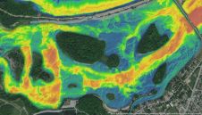
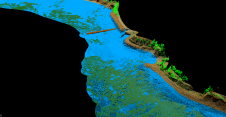
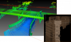
The Greater Montréal Area completed Canada’s largest-ever riverine topobathymetric Lidar survey in response to two major flooding events within the last five years, which together displaced tens of thousands of...
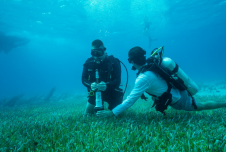
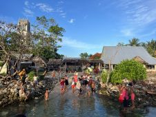
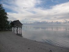
Hexagon is working with Beneath The Waves, a conservation NGO, to help protect marine environments in the Bahamas. Using bathymetric airborne Lidar solutions, researchers are able to map, study and...
This site uses cookies. By continuing to use this website, you agree to our Cookies Policy. Agree