MS400U MBES
The MS400U is a compact Multibeam Echosounder (MBES) specially designed for USVs or other unmanned platforms. It has a built-in sound velocity sensor and IMU & GNSS, which are the...
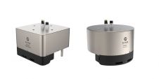
The MS400U is a compact Multibeam Echosounder (MBES) specially designed for USVs or other unmanned platforms. It has a built-in sound velocity sensor and IMU & GNSS, which are the...

By harnessing capabilities of advanced satellite technology and ever-evolving data analysis, satellite-based mapping (including satellite-derived bathymetry, SDB) offers an efficient, extensible and cost-effective method for mapping water properties, underwater topography...
The latest innovation from Exail, a prominent provider of maritime autonomy solutions, is the DriX O-16, a transoceanic uncrewed surface vessel (USV). With an impressive autonomy range of 2,500 nautical...

In the quest to unravel the mysteries beneath our planet’s water bodies, topobathymetric technologies emerge as a beacon of innovation. Among them, Lidar (light detection and ranging) and sonar sensors...

IHO standard S-44 is often used (or misused) to specify the quality of a hydrographic survey. While it is a useful tool, it is easy to misinterpret. One ‘misuse’ is...
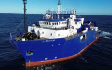
TDI-Brooks has strengthened its fleet with the RV Nautilus, a 75-metre DP2 vessel with enhanced capabilities that was built in 2000. This addition, which features the Geomil Manta-200 CPT system...
Manually examining the seafloor for objects such as wrecks requires a great deal of time and labour, both at sea and in the office. As time is a limited and...
In August 2012, UK-based Swathe Services & HydroCharting delivered the first in a series of new multibeam echo sounder (MBES) training courses designed to give hydrographic surveyors hands-on experience on...
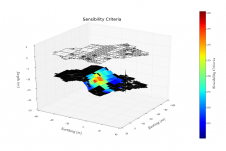
Currently, calibration of multibeam echosounders (MBES) for hydrographic surveys is based on the traditional ‘patch test’ method. This subjective method, although rigorous, has major drawbacks, such as being time-consuming (in...
In dynamic water environments such as the Maasgeul waterway off the Dutch coast at the Port of Rotterdam, tides and a varying presence of salt and freshwater from river run-off...
This site uses cookies. By continuing to use this website, you agree to our Cookies Policy. Agree