Uncovering the secrets of German marine munitions dumpsites
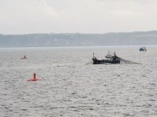
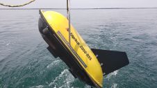
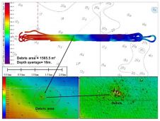
In November 2020, a team of researchers from GEOMAR and EGEOS embarked on an unusual round trip across the German Baltic Sea. Their mission was to shed light on the...
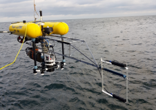
In November 2020, a team of researchers from GEOMAR and EGEOS embarked on an unusual round trip across the German Baltic Sea. Their mission was to shed light on the...
SHOM – the French national hydrographic service – is planning to replace most of its aging seagoing assets in the near future and, in this context, a four-week sea trial...
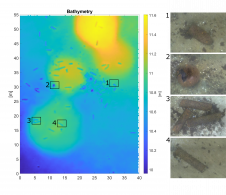
The detection of unexploded ordnance (UXO) in the sea is a demanding task. UXO survey data is acquired using a set of different sensors in different configurations and can span...
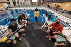
Autonomous underwater vehicles have become versatile tools for exploring the seas. However, they can be disruptive to the environment or have trouble travelling through confined spaces. Purdue University researchers are...
EdgeTech, one of the leading companies in high-resolution sonar imaging systems and underwater technology, has recently introduced a new combined tri-frequency sidescan sonar and high-resolution sub-bottom profiling sonar system. The...
Sriwijaya Air Flight 182 was an Indonesian domestic flight from Soekarno-Hatta International Airport in Jakarta to Pontianak, Indonesia. On Saturday 9 January 2021, the Boeing 737 crashed into the waters...

Kongsberg Maritime has announced the next generation of its advanced HUGIN Autonomous Underwater Vehicle (AUV). Named HUGIN Endurance, the new AUV boosts operational duration to approximately 15 days, enabling extended...
While nautical charting mainly focuses on bathymetry and objects that form a hazard to shipping, offshore construction and dredging require sub-bottom information. There is nothing worse in any project than...
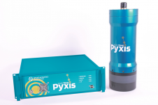
Applied Acoustic Engineering (AAE) has announced the launch of its next-generation USBL system, Pyxis USBL. Taking its name from the constellation Pyxis Nautica – the mariner’s compass – Pyxis USBL...
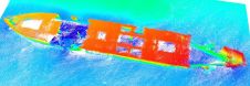
TDI-Brooks recently mapped the Liberty Ship George Vancouver Reef off Freeport, Texas while out on a seabed survey project with the RV Brooks McCall. The multiple multi-phase geophysical and geotechnical...
This site uses cookies. By continuing to use this website, you agree to our Cookies Policy. Agree