Hydro International #1- 2024
In a roundup of the hydrographic industry’s latest developments in multibeam echosounding technology, this issue dives into the depths of hydrographic survey data, uncovering advanced techniques and tools that are...
In a roundup of the hydrographic industry’s latest developments in multibeam echosounding technology, this issue dives into the depths of hydrographic survey data, uncovering advanced techniques and tools that are...
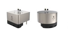
EM 2042 Multibeam Echosounder Small in size, but powerful in potential, the EM 2042 Multibeam Echosounder is efficient, light, robust and reliable: delivering high-density, high-resolution, clean data in the most demanding marine environments. With...
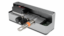
The MS400U is a compact Multibeam Echosounder (MBES) specially designed for USVs or other unmanned platforms. It has a built-in sound velocity sensor and IMU & GNSS, which are the...
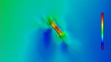
A 120-year-old mystery has been solved with the help of a CSIRO team aboard the RV Investigator. Heritage NSW has announced the discovery of the SS Nemesis, a 73-metre iron-hulled...

IHO standard S-44 is often used (or misused) to specify the quality of a hydrographic survey. While it is a useful tool, it is easy to misinterpret. One ‘misuse’ is...
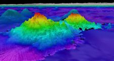
The crew of Schmidt Ocean Institute’s research vessel Falkor (too) recently discovered four underwater mountains – the tallest of which exceeds 2.4km in height – during a January transit from...
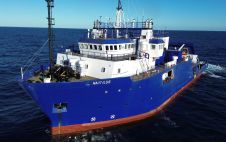
TDI-Brooks has strengthened its fleet with the RV Nautilus, a 75-metre DP2 vessel with enhanced capabilities that was built in 2000. This addition, which features the Geomil Manta-200 CPT system...

When contemplating the replacement of a research and survey fleet, a collective effort is required to meticulously curate an optimal new fleet, considering factors such as ship type, size, capabilities...
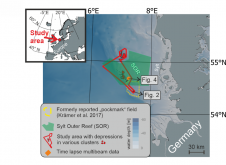
World oceans host diverse creatures that shape the seafloor. In a groundbreaking interdisciplinary study published in Communications Earth & Environment, Kiel University geoscientists, alongside biology and oceanography experts, have linked...
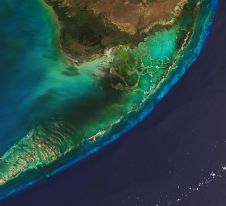
The Florida Department of Environmental Protection has commissioned Woolpert to acquire bathymetric survey data using Lidar technologies to support the Florida Seafloor Mapping Initiative (FSMI) and its mission to produce...
This site uses cookies. By continuing to use this website, you agree to our Cookies Policy. Agree