Norbit Training
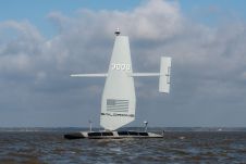
Saildrone announced the launch of its first aluminium Surveyor unmanned surface vehicle (USV) from the Austal USA production line in Mobile, Alabama. Chief of Naval Operations (CNO) Adm. Lisa Franchetti was...

Oceanology International 2024 (Oi24) is set to captivate attendees with a showcase of pioneering companies and innovative technologies, all poised to command attention at London's ExCeL. From advanced autonomous vehicles...

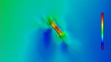
The presence of suspended sediments in water bodies presents significant challenges for the dredging industry. Existing methods to determine nautical depths are intrusive single point methods relying on in situ density or shear strength measurements1,3 or low-frequency single-beam echosounder recordings1,2. The use of single-beam echosounders is however systemically problematic as they are not practical in satisfying the CATZOC A1 coverages required for contemporary electronic navigational charting. The presence of suspended sediments in water bodies presents significant challenges for the dredging industry. Existing methods to determine nautical depths are intrusive single point methods relying on in situ...

Leading professionals from the ocean science and technology industries will gather at Oceanology International in London from 12–14 March. Oceanology International has announced a captivating lineup of esteemed industry leaders and...
Aspect Land & Hydrographic Surveys Ltd is one of the leading independent coastal survey companies in the UK, with extensive experience and a proven track record in providing high-resolution hydrographic,...
A 120-year-old mystery has been solved with the help of a CSIRO team aboard the RV Investigator. Heritage NSW has announced the discovery of the SS Nemesis, a 73-metre iron-hulled...

IIT Madras has established a Centre of Excellence (CoE) dedicated to advancing indigenous maritime technology and expertise. The team of researchers leading this initiative has been actively engaged in notable...

The Danish Geodata Agency, alongside several collaborators, is currently conducting trials on the latest iteration of navigational charts in the Baltic Sea region. This initiative forms part of an EU-funded...

NORBIT SUBSEA designs and develops wideband multibeam sonars for hydrographic applications, forward-looking applications as well as advanced subsea leakage detection. Our solutions are based on the latest in analog and...
This site uses cookies. By continuing to use this website, you agree to our Cookies Policy. Agree