VRS Systems for Improved Efficiencies in Port Operations
Mariners were one of the first public groups to adopt GPS in its early days Ð nearly twenty years ago. The next leap forward in the acceptance and widespread use...
Mariners were one of the first public groups to adopt GPS in its early days Ð nearly twenty years ago. The next leap forward in the acceptance and widespread use...
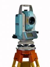
Nikon-Trimble has introduced today the NPR-302 Series of Nikon Total Stations - high precision, long-range reflectorless mechanical total stations with laser pointers. Each new model in the series offers Nikon...
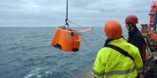
This is the continuation of the Oceanology International Preview. For companies A - L, see part 1 MacArtney Underwater Technology Group MacArtney will be introducing their newest innovation in multiplexers...
Ordnance Survey's goal of establishing standards in data collection and management has won industry recognition. The British national mapping agency's data production management methodology, termed Production Partnership Management (PPM), is...
The National Oceanic and Atmospheric Administration (NOAA), the US Environmental Protection Agency (EPA) and the White House Office of Science and Technology Policy (OSTP) have released its second peer-reviewed, analytical...
In the third week of March, the entire marine world will be gathering in London, as this is where the biannual Oceanology International event is taking place. The exhibition and...

Turner Designs offers a Deep UV Optical Kit for their C3 Submersible Fluorometer which enables detection of refined oils and fuels. Recent developments in LED technology allow for excitation wavelengths...
Unlike neighbouring Japan, earthquake activity is infrequent in the peninsula area of South Korea, and those that do occur tend to be low in intensity. Typically, earthquakes in this region...
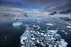
Experts have reconstructed the depth of the Southern Ocean at key phases in the last 34 million years of the Antarctic’s climate history. The glacial history of the Antarctic is...
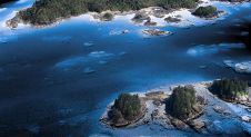
The National Oceanic and Atmospheric Administration (NOAA) contracted NV5 Geospatial to define the shoreline in an extremely complex area of south-east Alaska as part of the NGS Coastal Mapping Program....
This site uses cookies. By continuing to use this website, you agree to our Cookies Policy. Agree