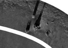
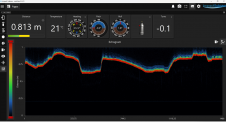
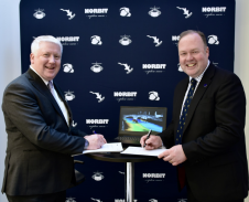
S-44 and the systematic error
IHO standard S-44 is often used (or misused) to specify the quality of a hydrographic survey. While it is a useful tool, it is easy to misinterpret. One ‘misuse’ is...
Combining the DriX uncrewed surface vehicle (USV) and the FlipiX remotely operated towed vehicle (ROTV), Exail has developed a unique solution enabling fully autonomous and remotely operated surveys. Combining the DriX uncrewed surface vehicle (USV) and the FlipiX remotely operated towed vehicle (ROTV), Exail has developed a unique solution enabling fully autonomous and remotely operated surveys. Accurate surveys...
Valeport's innovative approach to oceanographic instrumentation has resulted in a series of incremental improvements to their world-leading Sound Velocity sensors. Customers with existing products can also benefit from the product...
Assets on the seabed, such as offshore wind turbines, natural resource extraction systems and underwater cables, serve as critical subsea infrastructure. To efficiently build, monitor, protect and maintain these assets,...
Combining AUV and ROV capabilities in a modular, hybrid unit improves functionality, while subsea docking technology expands the operational window of such a vehicle, allowing it to carry out multiple...
Impact Subsea, a leading provider of underwater sensors, has announced the addition of a new feature to its ISA500 range of altimeters and echosounders – Echogram. This new feature adds a...
The global effort inspiring the complete mapping of the world’s ocean floor – The Nippon Foundation-GEBCO Seabed 2030 Project – has announced its newest partnership with Norbit Oceans, a leading...
Magellan, a deep-sea mapping company, and Atlantic Productions, a British television company, have embarked on an ambitious collaboration to conduct a comprehensive scan of the RMS Titanic. This iconic British...
An estimated 95% of the oceans remains unexplored today, implying a huge market opportunity for innovative marine survey solutions. While the boom in offshore renewables projects will certainly continue, the...
Underwater positioning with USBL can be accurate in favourable environments. However, it’s often perceived as less precise than land-based positioning. Maintaining high accuracy during mobilization and calibration is crucial. If...
This site uses cookies. By continuing to use this website, you agree to our Cookies Policy. Agree