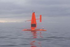
Saildrone presents new acoustic capabilities to protect marine mammals
As the demand for clean energy continues to grow, there has been a corresponding increase in the development of offshore wind farms to help meet energy needs. However, it is...
As the demand for clean energy continues to grow, there has been a corresponding increase in the development of offshore wind farms to help meet energy needs. However, it is...
MV Yolla, Deakin University’s 10-metre research vessel based in Warrnambool, Australia, was recently equipped with a Kongsberg EM2040C. Using the new multibeam system, students collected data about the local shipwreck...
The ocean plays a crucial role in mitigating climate change, yet we lack detailed information on over 95% of the seafloor. This article explores planblue’s solution to accelerate time-to-data and...
The TrueOcean Marine Data Platform (MDP) has recently seen the addition of a new geospatial search function that enables data on the platform to be located and accessed in seconds...

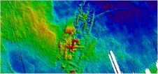
Fugro has utilized its cutting-edge hydrographic technology in Australia to locate the final resting place of the Montevideo Maru, which sank in 1942 with more than 1,200 people on board....
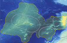
Portugal’s SEAMAP 2030 programme is on an unprecedented mission to meticulously chart the country’s maritime depths, contributing a vital piece of the global puzzle to the monumental GEBCO bathymetric grid....

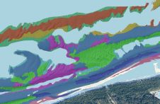
Andrijana Horvat is R&D lead geophysicist and GIS specialist at Hidrocibalae, with a Master’s in Geography from the University of Zagreb. Her professional interests include hydrography, GIS, Python programming and cartography,...

Dino Dragun is CEO and founder of Hidrocibalae, a marine geophysical data centre, with over ten years of experience in the offshore industry as a data processor/surveyor/party chief, covering geophysical...
Trimble, USA, released a preview version of its CenterPoint RTX post-processing service at ION GNSS 2013, enabling GNSS observations using available Galileo and BeiDou Middle Earth Orbit (MEO) satellites. Powered...
This article presents a novel methodological approach to understand and assess the suitability of airborne Lidar bathymetry for the automatic classification and mapping of the seabed. This solution allows recording of...
This site uses cookies. By continuing to use this website, you agree to our Cookies Policy. Agree