Cable inspections the uncrewed way
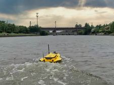
XOCEAN has completed 35 cable inspection surveys using a combination of uncrewed surface vessels (USVs) and uncrewed aerial vehicles (UAVs) between the Scottish mainland and Western Isles. There was a...
XOCEAN has completed 35 cable inspection surveys using a combination of uncrewed surface vessels (USVs) and uncrewed aerial vehicles (UAVs) between the Scottish mainland and Western Isles. There was a...
WASSP has released the latest version of its S3 dedicated hydrographic survey MBES with the roll-out of a new real-time processing module. The S3 is launched as one of the...
This article presents a participative geomatics project with the goal of increasing southern Québec’s coastal communities’ ability to map and monitor changes in their coastal environment. Capacity-building and empowerment using...
Students all over the world are finding it difficult to get the training that they need in the ongoing coronavirus pandemic. In this article, we see how a hydrographic training...
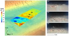
Hydrographic measurements are nowadays usually carried out using multibeam echosounders (MBES). The measurements obtained by each operational hydrographic vessel need to be regularly controlled on a well-known area to validate...
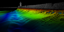
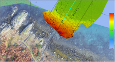
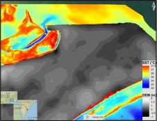
Norbit investigated whether there has been any displacement of the rocks that form the jetty of the Skansen Bridge, performing a multibeam and Lidar survey inspection of the jetty. Skansen is a historic area in the city of Trondheim in central Norway and home to the Skansen Bridge, a 52m span bascule railway bridge that opens for marine traffic...
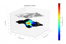
Currently, calibration of multibeam echosounders (MBES) for hydrographic surveys is based on the traditional ‘patch test’ method. This subjective method, although rigorous, has major drawbacks, such as being time-consuming (in...
This paper explores the various features of the Apache USV series for efficient seafloor-level mapping. The CHCNAV hydrographic survey software is used for data recording and analysis. It provides results...
Submarine groundwater discharge (SGD) is a significant part of the water cycle that delivers anthropogenically derived and naturally occurring nutrients to coastal waters. As part of the drive to develop...
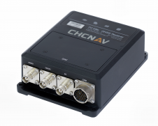
CHC Navigation (CHCNAV) releases the P2 GNSS Sensor Series providing high accuracy positioning and heading solution in a compact and rugged enclosure. The P2 GNSS Sensor series is the GNSS...
This site uses cookies. By continuing to use this website, you agree to our Cookies Policy. Agree