Research-driven Tools for Ocean Mappers
Current technologies can help ocean mappers and cartographers to fight repetitive, manual and error-prone routines the smart way. In a world where artificial intelligence is playing a key role in...
Current technologies can help ocean mappers and cartographers to fight repetitive, manual and error-prone routines the smart way. In a world where artificial intelligence is playing a key role in...
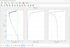
EdgeTech has released a new version of its Discover sonar software. The software coverage mapper module has advanced navigation features allowing the setup of survey lines with a left/right steering...
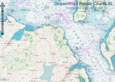
OceanWise has been awarded a contract to provide the Government of Northern Ireland with marine mapping. The agreement includes Marine Themes, Marine Themes DEM and Raster Charts XL (eXcluding Land)...

The International Board on Standards and Competence for Hydrographic Surveyors and Nautical Cartographers (IBSC) recognised and approved Coast Survey’s certification programme in cartography (CAT-B) at its 40th meeting in Wellington,...
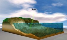
Bathymetric Lidar is the most effective and cost-efficient technology to capture both the land and sea floor simultaneously, in order to provide a continuous, detailed 3D elevation model along the...
A 94-page White Paper on ECDIS Type Specific covering all aspects from the 38 manufacturers to charting and training options is available for download. The white paper tackles the problem...
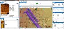
Teledyne CARIS has released Hydrographic Production Database (HPD) 3.2. As part of the CARIS Ping-to-Chart solution, HPD offers an integrated suite of products for managing data in a seamless database,...
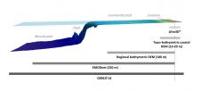
SHOM contributes routinely to the preparedness against coastal risks along French coastlines. For this purpose, regional to coastal digital elevation models are built for implementation in forecast systems against rapid...

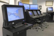
NOAA is one of the bigger organisations in the world that has surveying and charting in its portfolio. It’s an immense task as the USA has about 95,000 miles of coastline, important ports and a wide range of users – from recreational boaters to the biggest container vessels and tankers. The country also has to deal with environmental disasters like hurricanes and oil spills. NOAA is undergoing changes as the chart portfolio is ‘going digital’ and new initiatives such as using Maritime Autonomous Systems (MAS) for surveys. Hydro International interviews Capt Shep Smith, who generously gave an insight behind the scenes. NOAA is one of the bigger organisations in the world that has surveying and charting in its portfolio. It’s an immense task as the USA has about 95,000 miles of...
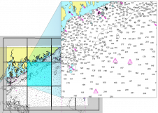
OceanWise, UK, has developed a set of specialist tools and methodologies to identify specific content from raster charts. By removing all content to the landward side of the coastline, OceanWise...
This site uses cookies. By continuing to use this website, you agree to our Cookies Policy. Agree