Live Demonstration of CARIS Onboard
During the Shallow Survey 2015 conference held in Plymouth, UK, Teledyne and CARIS showcased the latest capabilities in autonomous survey operations with a live demonstration. For this demonstration a Z-boat...
During the Shallow Survey 2015 conference held in Plymouth, UK, Teledyne and CARIS showcased the latest capabilities in autonomous survey operations with a live demonstration. For this demonstration a Z-boat...
UK-based OceanWise has developed a Maritime Toolbar (MTB) for ArcMap so maritime users on an Esri platform can take advantage of the functionality previously only available to Cadcorp SIS users....
The key objective of the NOAA Chart Adequacy Workshop was to demonstrate techniques to evaluate the suitability of nautical chart products using chart quality information and publicly-available information. The three-day...

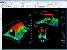
There are settings where an unmanned survey represents more than a safe, cost-effective alternative; it may be the only option. Capitol Lake in Olympia, WA, USA, is such a location....
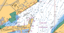
OceanWise, UK, has released free, interactive Marine Mapping product demonstrators. Built using OpenLayers, the demos allow the user to pan around a defined area and get a feel for different...
Chesapeake Technology (CTI, USA) has released its new processor engine specifically designed for high-volume interferometric sidescan sonar and shallow-water multibeam data. CTI has also enhanced import options for sidescan sonar...
FME 2015 by Safe Software is available in both FME Desktop and FME Server. Developments aim to help users easily move their data to where it needs to be and...
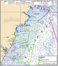
The Gulf of Maine is the first area to be surveyed by NOAA ships in 2015, with a hydrographic project scheduled for about 142 square nautical miles in January and...
Fugawi Aboard, from Northport Systems, is designed with new technology, combining US and Canadian raster charts based on National Oceanic Atmospheric Administration (NOAA) and Canadian Hydrographic Service (CHS) nautical charts...
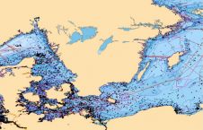
ChartWorld, Germany, offers the OceanWise Marine Themes dataset combining the fragmented features of traditional nautical charting merged into an almost seamless marine map. The resulting data is more beneficial and...
This site uses cookies. By continuing to use this website, you agree to our Cookies Policy. Agree