Backscatter - From Ping to Database
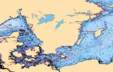
The Canadian Hydrographic Service (CHS) is willing to make better use of the backscatter intensity data collected with their multibeam sounding systems. All the backscatter data collected during the last...
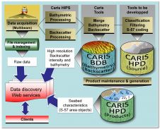
The Canadian Hydrographic Service (CHS) is willing to make better use of the backscatter intensity data collected with their multibeam sounding systems. All the backscatter data collected during the last...
UK-based OceanWise has been awarded the framework contract for the supply of marine mapping data to the Scottish government. This award means that OceanWise is now the supplier of choice...
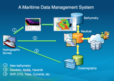
Traditionally, hydrographic data was used mainly for nautical charts. Hydrographic surveys are costly, and data should be used beyond navigation. Some have developed centralised hydrographic databases, but their only purpose...
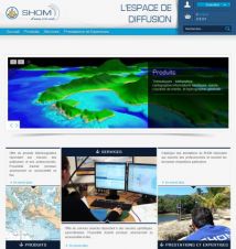
On 18 March 2014, SHOM launched its online distribution space: diffusion.shom.fr. An interactive selection feature allows the products to be visualised and selected conveniently. The platform presents information about the...
In keeping with its mandate to make data more accessible to as many people as possible, Land Information New Zealand (LINZ) is now offering its Raster Navigational Charts (RNCs) at...
After a three-month trial period, PDF versions of USA’s NOAA nautical charts will become a permanent product, at no cost to the public. The PDFs, which are digital images of...
Proteus FZC, UAE, has teamed with TCarta Marine, USA, to offer complete bathymetric data sets from the shallow near-shore coastal zone out to the continental shelf. Depending on water conditions,...
Independent marine data management and publishing specialist, OceanWise Ltd, UK, has established off-the-shelf marine mapping datasets for demanding applications. The Marine Themes vector mapping coverage has been extended for a...
The US Office of Coast Survey, National Ocean Service, National Oceanic and Atmospheric Administration (NOAA), Department of Commerce is privatising the printing and distribution of nautical charts, including digital charts,...
Safe Software and CARIS, Canada, have announced that support for the CARIS Spatial Archive (CSAR) raster format for gridded bathymetry and elevation data will be included in FME 2014, which...
This site uses cookies. By continuing to use this website, you agree to our Cookies Policy. Agree