Deadline Extended for OI China Abstracts
It is not too late to secure a speaking slot at China's premier marine science and ocean technology conference and exhibition, taking place from 3-5 November 2015 in Shanghai, as...

It is not too late to secure a speaking slot at China's premier marine science and ocean technology conference and exhibition, taking place from 3-5 November 2015 in Shanghai, as...
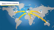
The Port of Rotterdam is Europe’s largest port and is one of the world’s key logistic hubs. Hydrographic data is critical to the Harbour master’s department for the operation of the Port of Rotterdam, to support the nautical accessibility of the deep-sea vessels by electronic nautical chart. The introduction of PortMaps enables the Port of Rotterdam to produce a wide variety of information products, including ENCs, from the Port’s survey data, in less than 48 hours. With over 500 line connections to and from more than 1,000 ports around the globe, the Port of Rotterdam in The Netherlands is the cornerstone of international freight transport. It is the...
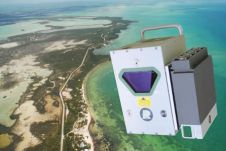
Fugro has commissioned an additional airborne laser bathymetry system to underpin its development and application of bathymetric Lidar technology. The combined Fugro LADS Mk3 and Riegl VQ-820-G systems provide seamless...
Ocean Business 2015, taking place from 14-16 April 2015 at the National Oceanography Centre in Southampton, UK, is presenting one of its most impressive training and demonstration line-ups yet. With...
FME 2015 by Safe Software is available in both FME Desktop and FME Server. Developments aim to help users easily move their data to where it needs to be and...
The RIEGL laser scanner company has been innovating laser scanning technology for more than 30 years. The equipment can be found in the most remote and even challenging locations across...
Hydrography has seen a decrease in capacity, with fewer survey ships available for surveys around the globe. Although there are certain regional differences, which means a decrease in some regions...
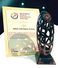
On 15 May 2013, RIEGL won the Geospatial World Award in the category Geospatial Technology Innovation Surveying at the Geospatial World Forum Conference in Rotterdam, The Netherlands, for the RIEGL...
Laser scanning specialist 3D Laser Mapping, UK, and laser scanning manufacturer RIEGL, Austria, are attending Ocean Business for the first time this year. Taking place from 9 to 11 April...
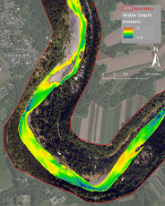
In September 2012, Watershed Sciences, Inc. (WSI) and Dewberry collected airborne topobathymetric Lidar data for the Sandy River in Oregon, USA. These data are being used to map channel and...
This site uses cookies. By continuing to use this website, you agree to our Cookies Policy. Agree