Amplified Sediment Waves in the Irish Sea (AmSedIS)
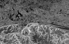
Large sediment waves are striking yet poorly understood seabed features in many shelf seas. Very large sediment waves (3–18m in height) have been documented to migrate up to 70m per...
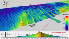
Large sediment waves are striking yet poorly understood seabed features in many shelf seas. Very large sediment waves (3–18m in height) have been documented to migrate up to 70m per...
Flanders, Belgium, is taking a leap forward into the next generation of bathymetric measurement technology. The economic development of the maritime industry in Flemish harbours demands new and advanced technologies...
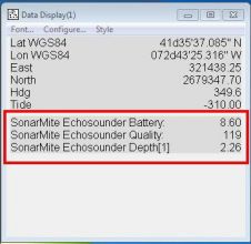
The SonarMite.dll is a singlebeam echosounder driver for the Ohmex SonarMite SBES. Having remained unchanged since it was first written years ago, it has now been updated. It appears also...
There are currently 13,764 Marine Protection Areas (MPAs) jointly covering over 2% of the oceans. One such MPA is Malaysia’s newly formed Tun Mustapha Park comprising 1 million hectares of...
Hydrographic surveying in ultra-shallow, inland and enclosed waters can prove extremely challenging and often presents increased risks and obstacles to both personnel and equipment. These considerations include health and safety...
While 70% of the Earth is covered by water, very little of it has been surveyed so far (Mars, Venus and the Moon are better surveyed). The techniques for doing so...
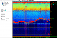
Teledyne PDS has released a new view to display singlebeam echogram data and to control the singlebeam device. The Online SBES Echogram view and features have been developed to enable...
The primary role of the Survey Engineer will be to provide technical support on all survey equipment and software owned and sold to customers by the company. The position is...
FarSounder is the most recent company to join the International Hydrographic Organization’s Crowd-Sourced Bathymetry (CSB) initiative by becoming a “trusted node” with the NOAA. This project enables mariners to voluntarily...
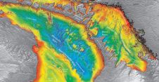
This article will immerse you in the deep water of bathymetry. It explains in detail what a bathymetric map is, what it shows, what methods we use to collect the...
This site uses cookies. By continuing to use this website, you agree to our Cookies Policy. Agree