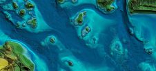
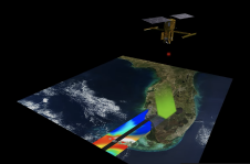
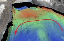
Found 1314 results
Sort by

Satellite Positioning

Within the last twenty years Global Positioning System (GPS) receivers have revolutionised navigation. Integrated devices are capable of providing time, position, height, direction, heave and attitude to accuracies of a...

Read more

Satellite Navigation

Over the last twenty years Global Positioning System (GPS) receivers have revolutionised navigation. Integrated devices are capable of providing time, position, height, direction, heave and attitude, to accuracy of a...

Read more

Mapping northern Greenland waters

An understanding of the interplay between glaciers and the ocean is needed to improve sea-level rise projections. Seafloor mapping is critical in this pursuit, particularly where the ice sheets of...

Read more

Improving Satellite-derived Bathymetry

Bathymetry is traditionally acquired using singlebeam or multibeam echosounders. This method produces accurate depth measurements along transects but is constrained by operating cost and an inability to survey in very...

Read more

Landsat Satellite Spots Shipwrecks

An estimated three million shipwrecks are scattered across the planet’s oceans. Most maritime mishaps occur close to shore where hazards to navigation — such as rocks, reefs, other submerged objects and...

Read more