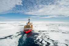
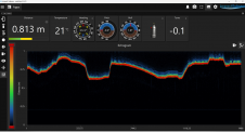
Mapping northern Greenland waters
An understanding of the interplay between glaciers and the ocean is needed to improve sea-level rise projections. Seafloor mapping is critical in this pursuit, particularly where the ice sheets of...
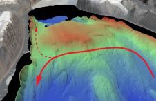
An understanding of the interplay between glaciers and the ocean is needed to improve sea-level rise projections. Seafloor mapping is critical in this pursuit, particularly where the ice sheets of...
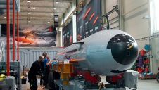
Kongsberg Discovery has embarked on an ambitious journey, commencing an extensive series of sea trials with its latest groundbreaking creation: the HUGIN Endurance autonomous underwater vehicle (AUV). Launched in 2021,...
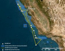
From 21 October to 11 November, NOAA Ocean Exploration is leading expeditions aboard the NOAA Ship Okeanos Explorer off the coast of central California and within the boundaries of the...
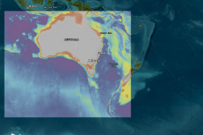
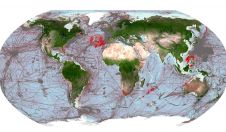
More than 1,500 individual seabed surveys have been combined to give sectors such as marine park management and offshore renewable industries – as well as storm surge modellers – a...
Working in the ocean environment can be challenging and dangerous. It requires skilled professionals using cutting-edge technology to measure and map the physical features of the underwater environment, whether for navigational safety, coastal zone management, mapping of physical structures or seabed topography. Often, data is collected in remote locations or locations with unpredictable and harsh weather conditions. Working in the ocean environment can be challenging and dangerous. It requires skilled professionals using cutting-edge technology to measure and map the physical features of the underwater environment, whether for...
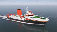
Kongsberg will supply Germany’s forthcoming 125-metre ocean research vessel, Meteor IV, with a range of highly advanced scientific sensors and handling equipment. Scheduled for launch in 2026, Meteor IV is...

David Millar is Fugro’s government accounts director for the Americas, based in the Washington DC area. He oversees the development and execution of partnerships with national governments, the United Nations,...
Delving into the mysteries of the planet’s final frontier – the ocean – has long captivated human curiosity, with the origins of ocean exploration dating back to 5,000 BC. But...
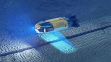
Combining AUV and ROV capabilities in a modular, hybrid unit improves functionality, while subsea docking technology expands the operational window of such a vehicle, allowing it to carry out multiple...
Impact Subsea, a leading provider of underwater sensors, has announced the addition of a new feature to its ISA500 range of altimeters and echosounders – Echogram. This new feature adds a...
This site uses cookies. By continuing to use this website, you agree to our Cookies Policy. Agree