120-year maritime mystery of lost steamship unravelled
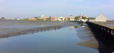
A 120-year-old mystery has been solved with the help of a CSIRO team aboard the RV Investigator. Heritage NSW has announced the discovery of the SS Nemesis, a 73-metre iron-hulled...
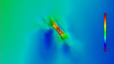
A 120-year-old mystery has been solved with the help of a CSIRO team aboard the RV Investigator. Heritage NSW has announced the discovery of the SS Nemesis, a 73-metre iron-hulled...

IIT Madras has established a Centre of Excellence (CoE) dedicated to advancing indigenous maritime technology and expertise. The team of researchers leading this initiative has been actively engaged in notable...
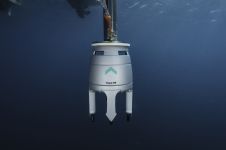
Grandeur Subserv, a company specializing in underwater and environmental engineering services, recently acquired an Exail Gaps M5 USBL system for shallow water geophysical surveys on the Nigerian coast. In search...
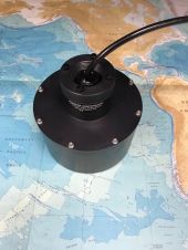
Unabara, a manufacturer of innovative tools for shallow water hydrography and oceanography, has announced its Hydro-2F Multi-Frequency Synthetic Beam Bathymetric & Sea Floor Sonar. The new solution provides both 200Khz...
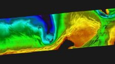
A recent article provides an overview of satellite-derived bathymetry methods and how data can be integrated into survey campaigns, and showcases three use cases. Bathymetric data in shallow-water zones is...
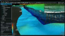
At the EIVA Day Brazil 2016 on 21 June in Rio de Janeiro, we'll take you through the solutions dedicated to shallow water jobs. The common denominator of all these...
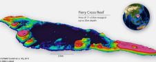
Hydrographic surveys in very shallow waters can have several applications such as nautical chart updating, performing environmental monitoring and characterisation, determination of dredged volumes, establishing navigational channels or defining general...
The EIVA NaviSuite software suite now includes a single-user sensor data acquisition and processing bundle for shallow water surveys, NaviSuite Kuda. The products and solutions presented at the Shallow Survey...
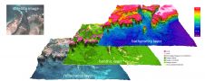
EOMAP Asia Pacific has launched a detailed dataset for the islands in the South China Sea, generated by satellite-derived bathymetry (SDB) techniques. The islands of the South China Sea are...
Leica Geosystems and Airborne Hydrography AB have presented Chiroptera II, a Lidar solution for topographic mapping and shallow-water surveying in depths of up to 15 metres. The system simultaneously captures...
This site uses cookies. By continuing to use this website, you agree to our Cookies Policy. Agree