Found 5060 results
Sort by

Mapping through fluid mud

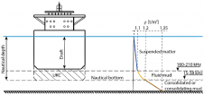
The presence of suspended sediments in water bodies presents significant challenges for the dredging industry. Existing methods to determine nautical depths are intrusive single point methods relying on in situ density or shear strength measurements1,3 or low-frequency single-beam echosounder recordings1,2. The use of single-beam echosounders is however systemically problematic as they are not practical in satisfying the CATZOC A1 coverages required for contemporary electronic navigational charting. The presence of suspended sediments in water bodies presents significant challenges for the dredging industry. Existing methods to determine nautical depths are intrusive single point methods relying on in situ...

Read more

Shallow-water Survey in Canada

Canada is the second largest country in the world, with a shoreline measuring approximately 243,800km, more than six times the circumference of the Earth. The Canadian Hydrographic Service (CHS), established...

Read more

Cable Tracking in Shallow Water

Whilst there has been an increased effort to resolve the issues of supporting deepwater construction operations, issues specific to shallow-water operations seem to have been largely overlooked, the attitude being...

Read more

EM 2042

EM 2042 Multibeam Echosounder Small in size, but powerful in potential, the EM 2042 Multibeam Echosounder is efficient, light, robust and reliable: delivering high-density, high-resolution, clean data in the most demanding marine environments. With...

Read more

Slocum Glider

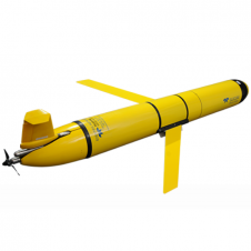
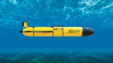
The Slocum glider is buoyancy-driven to enable long-range and duration remote water column observation for academic, military, and commercial applications. It can be deployed and recovered from any size vessel with minimal time on station The Slocum glider is buoyancy driven to enable long range and duration remote water column observation for academic, military, and commercial applications. The Slocum Glider can be deployed and recovered...

Read more

First Fully-autonomous Shallow Water Survey

Geodata specialist Fugro has completed the Middle East’s first fully autonomous geophysical shallow-water route survey. Controlled from their remote operations centre in Abu Dhabi, an unmanned surface vessel (USV) captured...

Read more