iXblue’s Sub-bottom Profiler Solution
The need for lake & river surveys constantly increases as human activity expands in these areas. While navigation remains a main focus, nowadays other applications such as hydraulic construction inspection,...

The need for lake & river surveys constantly increases as human activity expands in these areas. While navigation remains a main focus, nowadays other applications such as hydraulic construction inspection,...

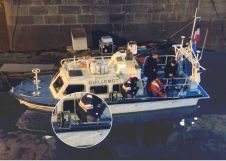
MMT (Sweden) has successfully completed a survey which includes the capture of parametric sub-bottom profile (SBP) data with a Kongsberg TOPAS PS 40 system. The system was hull-mounted on MMT's...
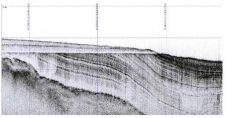
Knudsen Engineering have put their new 15kHz Pinger sub-bottom profiling system through its paces on Lake Champlain Vermont with the support of Middlebury College on their research vessel R/V Baldwin....
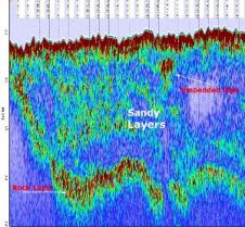
General Acoustics has presented the new SUBPRO 1210 Sub-Bottom Profiler the first time in public last Autumn in Aberdeen. At this occasion, a little survey for the Chief Surveyor of...
EdgeTech has introduced the new 3100 Sub-Bottom Profiling System, a portable solution for sub-bottom imaging. The system uses Full-Spectrum (‘chirp’) pulses to create high-definition image slices of the sub-bottom structure....

In the quest to unravel the mysteries beneath our planet’s water bodies, topobathymetric technologies emerge as a beacon of innovation. Among them, Lidar (light detection and ranging) and sonar sensors...

Oceanology International 2024 (Oi24) is set to captivate attendees with a showcase of pioneering companies and innovative technologies, all poised to command attention at London's ExCeL. From advanced autonomous vehicles...
iXBlue, France, is providing ECHOES sub-bottom profilers and DELPH seabed mapping software to SHOM for shallow-water hydrographic applications. SHOM missions include ensuring safety of navigation, defence support and public policies...

The presence of suspended sediments in water bodies presents significant challenges for the dredging industry. Existing methods to determine nautical depths are intrusive single point methods relying on in situ density or shear strength measurements1,3 or low-frequency single-beam echosounder recordings1,2. The use of single-beam echosounders is however systemically problematic as they are not practical in satisfying the CATZOC A1 coverages required for contemporary electronic navigational charting. The presence of suspended sediments in water bodies presents significant challenges for the dredging industry. Existing methods to determine nautical depths are intrusive single point methods relying on in situ...
This site uses cookies. By continuing to use this website, you agree to our Cookies Policy. Agree