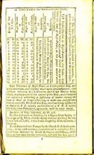
Tide Prediction in Colonial America
Although tidal ranges in America are, in general, less than in Europe, they have still had an impact on history. Many harbours were only accessible with high tide, introducing a...
Although tidal ranges in America are, in general, less than in Europe, they have still had an impact on history. Many harbours were only accessible with high tide, introducing a...

The end of April usually brings the first signs of harmful algae in USA's New England waters, and this year, researchers from the Woods Hole Oceanographic Institution (WHOI) and North...
Hydrographic surveying has become a highly sophisticated operation, with GPS for accurate fixing of position, acoustic technology for mapping the sea-bed either side of the survey vessel, and on-board computer...
The DIRECCION GENERAL ADJUNTA DE HIDROGRAFIA Y CARTOGRAFIA (DIGADIHCAR) has a national tide and meteorology network. Transmission of data is done both by satellite communication and by telephone links to...
RBR Ltd. has introduced the TWR-2050, a new compact submersible tide and wave recorder. The unit, with both burst modes and averaging, is capable of recording tide and wave data...
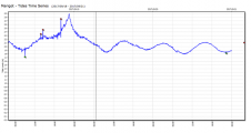
Hurricane Maria caused widespread damage on the Caribbean island of Dominica on the night of 19-20 September. Data from the OceanWise and GIS SRL monitoring station installed on the island's east...
UK-based Valeport has reported a surge in sales of tide gauge equipment in its most recent quarter. The manufacturer of oceanographic, hydrographic and hydrometric instrumentation said that sales of tide gauge...
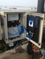
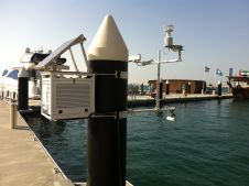
Valeport has introduced a self-contained tidal observation solution, the TideStation, which optimises performance of instrumentation and provides a simple-to-install and easy-to-maintain tidal observation hub. It has been designed to be...
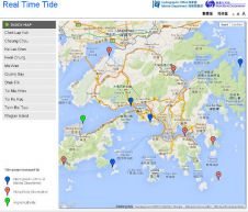
The Hydrographic Office of the Marine Department in Hong Kong has launched a real-time tide map. It displays the real-time tides at eleven locations along the Hong Kong shore, from...
C-Nav, USA, has launched its GNSS real-time tide measurement package, C-Tides. The suite combines the vertical accuracy of C-Nav's GNSS Precise Point Positioning service with ocean and coastal tide models....
This site uses cookies. By continuing to use this website, you agree to our Cookies Policy. Agree