The evolution of Dutch hydrography
Given the Netherlands’ geographical location, it is unsurprising to find it has a long tradition of hydrography. The lowland, often below sea level, forms a delta where major rivers from...

Given the Netherlands’ geographical location, it is unsurprising to find it has a long tradition of hydrography. The lowland, often below sea level, forms a delta where major rivers from...

Collaborating and coordinating are two very important tasks of EuroGOOS, the European Global Ocean Observing System, located in Brussels. The member organizations work together to share ocean observation data and...

By harnessing capabilities of advanced satellite technology and ever-evolving data analysis, satellite-based mapping (including satellite-derived bathymetry, SDB) offers an efficient, extensible and cost-effective method for mapping water properties, underwater topography...

Narcisa Pricope is an associate vice president for research in the Office of Research and Economic Development at Mississippi State University and a professor in the Department of Geosciences. Prior...

In the quest to unravel the mysteries beneath our planet’s water bodies, topobathymetric technologies emerge as a beacon of innovation. Among them, Lidar (light detection and ranging) and sonar sensors...
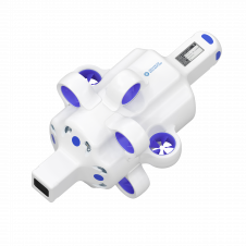
Hydrus is a micro-autonomous underwater vehicle that makes marine surveying easy and affordable. Hydrus takes the drone revolution underwater with the most advanced navigation and communication systems of any subsea...

How do you perceive prospects in the hydrographic surveying industry in 2024, compared to the past couple of years? When contemplating the hydrographic sector holistically, which areas of investment do...

The Republic of Cabo Verde, an archipelago located 500km off the west coast of Africa in the Atlantic Ocean, has taken a stride towards improving its hydrographic capacity by becoming...
Teledyne Marine announces the inauguration of a service centre for autonomous underwater vehicles (AUVs) in Poland. Established in collaboration with Enamor, this venture underscores its ambition to deliver exceptional support...
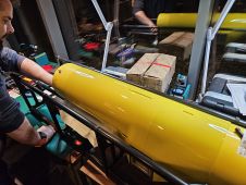
Combining the DriX uncrewed surface vehicle (USV) and the FlipiX remotely operated towed vehicle (ROTV), Exail has developed a unique solution enabling fully autonomous and remotely operated surveys. Combining the DriX uncrewed surface vehicle (USV) and the FlipiX remotely operated towed vehicle (ROTV), Exail has developed a unique solution enabling fully autonomous and remotely operated surveys. Accurate surveys...
This site uses cookies. By continuing to use this website, you agree to our Cookies Policy. Agree