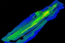
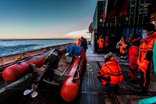
Found 137 results
Sort by

This Is How Airborne Multibeam Lidar Coastal Mapping is Done in Paradise

The Rapid Airborne Multibeam Mapping System, RAMMS, was developed over a period of three years before it was officially launched in the summer of 2018. Senior hydrographer Richard Goosen describes how Fugro used the system for coastal and nearshore mapping at the paradisal Turks and Caicos Islands. Insight into the use of the Rapid Airborne Multibeam Mapping System (RAMMS) for coastal and nearshore mapping at the paradisal Turks and Caicos Islands. The Rapid Airborne Multibeam Mapping System,...

Read more

Recent Developments in Airborne Lidar

The arrival of airborne Lidar, also referred to as airborne laser scanning (ALS), has revolutionized area-wide 3D data acquisition of topography, bathymetry, vegetation, buildings and infrastructure. This article presents an...

Read more