Observing the ocean together
Collaborating and coordinating are two very important tasks of EuroGOOS, the European Global Ocean Observing System, located in Brussels. The member organizations work together to share ocean observation data and...

Collaborating and coordinating are two very important tasks of EuroGOOS, the European Global Ocean Observing System, located in Brussels. The member organizations work together to share ocean observation data and...

Between January 2023 and February 2024, TDI-Brooks, a specialized company in geotechnical and offshore survey projects, conducted an extensive site investigation programme across two offshore wind blocks in state and...

By harnessing capabilities of advanced satellite technology and ever-evolving data analysis, satellite-based mapping (including satellite-derived bathymetry, SDB) offers an efficient, extensible and cost-effective method for mapping water properties, underwater topography...

Corey Goodrich is a majority owner and managing partner of TCarta, a small Denver, CO-based business specializing in satellite-based innovative technologies for improved modelling and understanding of shallow water and...
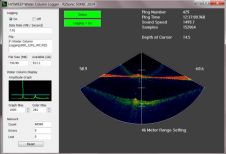
HYPACK, USA, has presented its new HYSWEEP Water Column Logging Routine. The HYSWEEP Water Column Logger is an application that collects and logs the enormous amounts of water-column data provided...
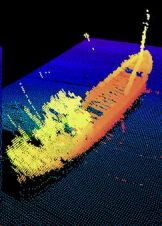
Norbit US has been awarded a contract from the Department of Homeland Security. The assignment was defined as a consequence of the Deepwater Horizon oil spill in the Gulf of...
CARIS' HIPS and SIPS is to integrate water column imaging. Version of HIPS and SIPS 7.1.1, scheduled for release in January 2012, allows differences in the water column data to...
Kongsberg Maritime’s new multi-beam echo sounder, EM 3002, extends the functionality of multi-beam echo sounders to cover 3D imaging of biomass and other acoustic reflectors that might be present in...
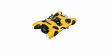
Hydromea, an industry leader in high-speed subsea communications and portable underwater inspection robotics, introduced a groundbreaking product at Oceanology International 2024 in London. The event marked the official commercial launch...
Measuring suspended particulate matter in the water column is still a big challenge when it comes to covering large areas in the sea or rivers. A novel method to monitor particles...
This site uses cookies. By continuing to use this website, you agree to our Cookies Policy. Agree